
Home
Preamble
Index
Areas
Dales
Hills
Lakes
Places
Reserves
Rivers
Structures
Villages
References
Me
Saunterings: Walking in North-West England
Saunterings is a set of reflections based upon walks around the counties of Cumbria, Lancashire and
North Yorkshire in North-West England
(as defined in the Preamble).
Here is a list of all Saunterings so far.
Guaranteed ad-free, AI-free and free!
If you'd like to give a comment, correction or update (all are very welcome) or to
be notified by email when a new item is posted - please send an email to johnselfdrakkar@gmail.com.
240. Turning Again to Whittington
For my first outing of 2026 I took the bus to Arkholme, aiming to walk up-river to
Kirkby Lonsdale. The valley here is wide, open and quiet, with the river far from any road.
So I anticipated a brisk but not too taxing stroll.


Left: Bay Horse, Arkholme; Right:
The first real view of the river
From the Bay Horse, I walked down Arkholme's cul-de-sac, past the church
and along the path that passes under the Carnforth-Wennington railway line.
Once past Lower Broomfield Farm I was on the open fields.
To begin with, there was some difficulty crossing these fields.
It is tempting to try to walk along the river's edge because then you do at least
know where you are.
However, there is Newton Beck and a number of inlets and pools marking old courses
of the river which
it is necessary to detour around.
It is better to forget about the river for a while and just follow
an embankment that curves away west.
Eventually you reach a clump of trees where the river rejoins you.
One's first thought on reaching this point is to pause and admire the fine
view across the river of Barbon Fell, Gragareth and Whernside, with on this occasion their
tops in white cloud.

The view over the river to Barbon Fell and Gragareth
The second thought is to look nearer to foot. It is not wise to go near the
river's edge as it continues to be eroded. Tracks end abruptly at
a new river edge. The bank is unprotected and seems to consist only of soil that
a river could easily wash away.
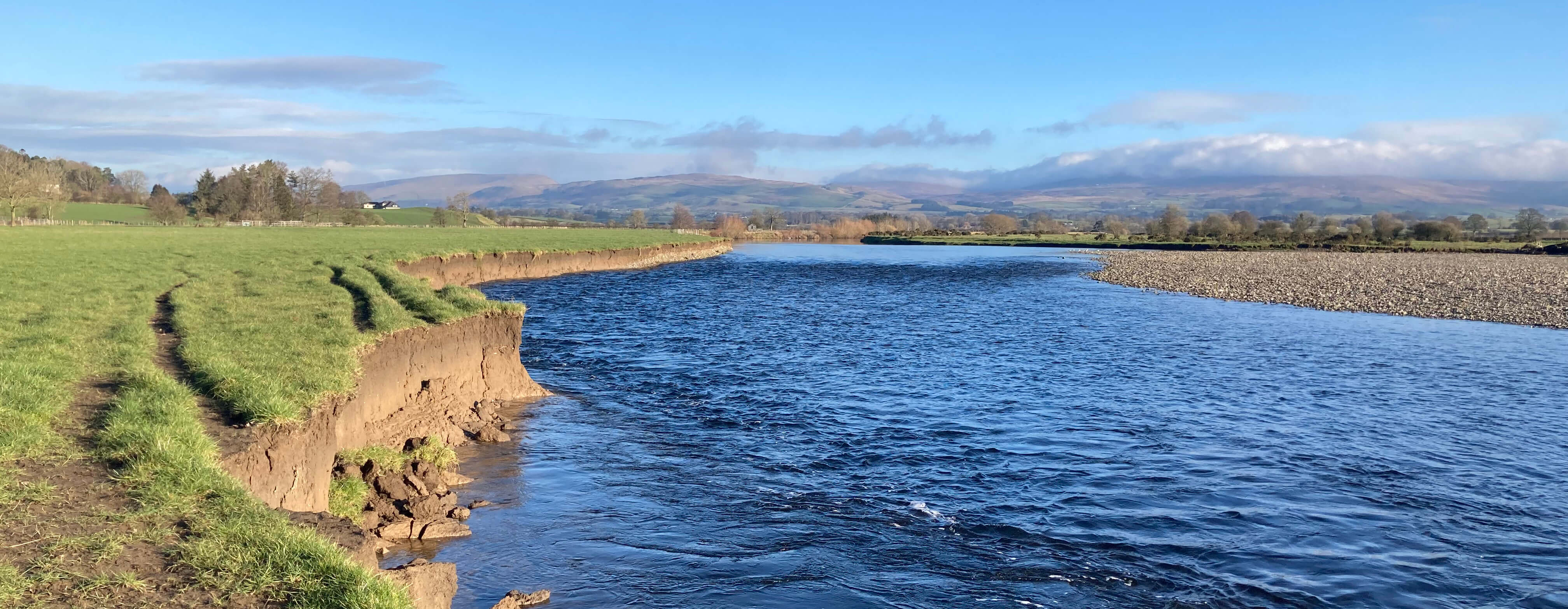
Showing the erosion of the bank
Further along there's a fence near the river edge which at first you walk on the
landward side of and then on the river side.
After a couple more fields I left the riverside to walk along a track
(Coneygarth Lane)
to the village of Whittington. This is a tiresomely muddy track that
I won't walk along again in a hurry. In fact, nobody could walk along it in a hurry.
At last the track reached the road, which I crossed to take a path heading
straight for Whittington church.
Since it is still the pantomime season, I'd like to
mention here that this village was the birthplace of Dick Whittington . . .
Oh no it wasn't.
Please don't interrupt. I was going to go on to say that although I'd like to
mention this I can't because he was actually born in Gloucestershire in about 1354.
I don't know where his cat was born.
Whittington has a very long history, being even older than Dick.
Before the Norman Conquest it was the
most important township in the region, being the base of a large lordship held by
Earl Tostig, brother of King Harold.
According to a history
of Whittington, "the importance of Whittington in 1066 as the head of a lordship did not
survive the Conquest, and the later history of the parish has been singularly uneventful".
That's a long time to be uneventful.
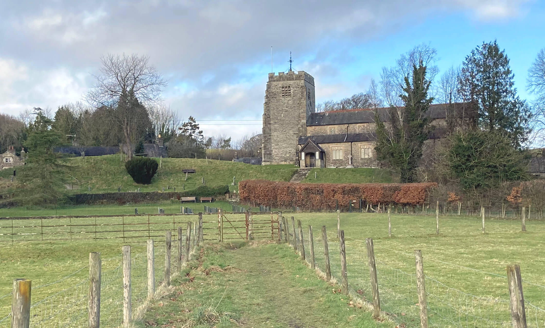 Right: Approaching St Michael's Church, Whittington.
The church is not so old. The tower is of the 16th century but the rest is fairly
modern and not special, to my eyes. The church is said to be on the site of
a motte and bailey castle and I don't doubt that the experts are correct – but I find
it hard to tell where the motte was (is the church on the motte, or was the motte
the hump to the west?).
From the church I walked up towards Whittington Hall.
This hall is one of the more impressive of the many halls that dot both sides of
the Lune valley. In the 25 miles between Sedbergh and Lancaster there are about 30 Halls
marked on the OS Explorer maps. There are also a number of other Hall-like buildings
that are called Houses, Granges or Manors (plus two Castles). I am tempted to list all the Halls but there
is some arbitrariness about what to include. For example, my own small village has a
Hall, an Old Hall, and an Old Hall Farm but none of them is named on the map or
has played a significant part in the
history of the region. On the other hand, there are important buildings that everyone
knows to be called Halls that are not marked as such on the map, for example, Underley Hall.
Most of the Halls were of much greater importance in the past than they are today.
Some historic Halls are now farms much like other farms.
Oh ok, I'll yield to temptation: here is a list of some of the Halls between Sedbergh and Lancaster (from north
to south, the indented Halls being on the east bank, the others on the west bank, and
with the number on the right indicating a Sauntering past it):
                   Grid ref
      Ingmire       SD6391  219
   Capplethwaite    SD6291
   White            SD6191
   Killington       SD6189
      Beckside      SD6388
      Middleton     SD6287
   Harprigg         SD6087
      Hawking       SD6185
   Rigmaden         SD6184
      Barwick       SD6283
   Nether           SD6082
   Mansergh         SD6081
      Whelprigg     SD6381  139
   Underley         SD6180
      Casterton     SD6179
      Kirfit        SD6179
   Biggins          SD6078  181
   Sellet           SD6077
   Whittington      SD5976
      Burrow        SD6175
   Newton           SD5974
      Tunstall      SD6073
      Wrayton       SD5972
      Melling       SD5971
   Storrs           SD5771
   Gressingham      SD5769  213
      Claughton     SD5766   93
      Gresgarth     SD5363
   Halton           SD4964  236
Since I am not often invited to set foot in any of these Halls
I can only form an opinion about them from what I can
see and read about them. Unfortunately I could not see much of Whittington Hall.
Grassy banks prevent anyone on the road seeing more than the chimneys.
I did trespass a few yards through a gate but trees blocked the view.
I didn't persevere: anyone who values their privacy deserves it.
 Left: A painting of Whittington Hall of about 1846.
I read that Whittington Hall was built in the Jacobethan style
in the 1830s for Thomas Greene, MP for Lancaster.
Today it is owned by Lord and Lady Reay (Aeneas Simon Mackay and Mia Reay, nee Ruulio).
Lord Reay is a member of the House of Lords, as an elected hereditary peer – that is,
elected by other hereditary peers not by us.
He is also chief of Clan Mackay. So why is he here in Lancashire and not with his
clanspeople in Scotland? I remember being at a village in Strathnaver
in north Scotland where everybody was named Mackay. I'm sure they'd welcome his
presence since
Lord Reay may be the origin of the saying that it is never difficult to distinguish
between a Scotsman and a Reay of sunshine.
Perhaps Lady Reay is reluctant to move to north Scotland as she is
a renowned interior designer, specialising in wallpaper, and needs to be able
to commute to the fashion houses of London.
I am a little surprised that wallpaper is still in fashion with the refined wealthy.
I remember helping my dad wallpaper our council house.
This was the only occasion when my dad found me of any use, mainly to take
the blame. Has the activity of wallpapering changed? Do you still need
buckets of paste to slop everywhere? Or have they invented self-adhesive
wallpaper? And wallpapering is the easy part.
De-wallpapering is the most tedious way to waste a few days of your life.
I see from the Mia Reay webpage
that Whittington Hall serves as an exhibition of her designs, ensuring that the hall
is a "model of timeless elegance".
Needless to say, it isn't to my taste because I haven't got any.
However, I wouldn't object to a splash in the "huge heated swimming pool".
And, if necessary, making use of one of the twenty bathrooms.
That's the least I deserve after this free advertisement.
I walked up Hosticle Lane, a track-cum-lane that hasn't cum far enough,
to Sellet Hall. This is marked in old font on the map but what I could see
of the group of buildings didn't enable me to identify any of them as Sellet Hall.
I had intended to walk on past Sellet Hill to Sellet Mill but a more
distinctive building to the north caught my eye.
This was Biggins Home Farm, with a red tiled roof unusual in these parts.
It is, unlike most farms in the region, not a vernacular building, having
been built relatively recently, in 1893.
Flagging a little now, I walked past the rows of
neat cottages in Low Biggins to Kirkby Lonsdale,
whose residents may be wondering why I did not include their Lunesdale Hall
(or, to be precise, The Lunesdale Hall) in
the list above.
Well, you can't just rename the Institute (as was done in 2013) and
expect it to be regarded as a historic hall, even if you give it a name
that suggests that it is the preeminent Hall serving the whole of Lunesdale.


Left: Biggins Home Farm; Right:
The Lunesdale Hall
Date: January 16th 2026
Start: SD583722, Arkholme bus stop (Map: OL2)
Route: (linear) SE on Main Street – church – NW on Lune Valley Ramble –
Coneygarth Lane – N, NE – Whittington – N on Hosticle Lane – Sellet Hall – N, NE – Low Biggins
– N, E, N – Kirkby Lonsdale
Distance: 7 miles; Ascent: 90 metres
Home
Preamble
Index
Areas
Dales
Hills
Lakes
Places
Reserves
Rivers
Structures
Villages
References
Me
© John Self, 2018-

Top photo: Rainbow over Kisdon in Swaledale;
Bottom photo: Ullswater