
Home
Preamble
Index
Areas
Dales
Hills
Lakes
Places
Reserves
Rivers
Structures
Villages
References
Me
Saunterings: Walking in North-West England
Saunterings is a set of reflections based upon walks around the counties of Cumbria, Lancashire and
North Yorkshire in North-West England
(as defined in the Preamble).
Here is a list of all Saunterings so far.
Guaranteed ad-free, AI-free and free!
If you'd like to give a comment, correction or update (all are very welcome) or to
be notified by email when a new item is posted - please send an email to johnselfdrakkar@gmail.com.
248. Whernside in the Wind
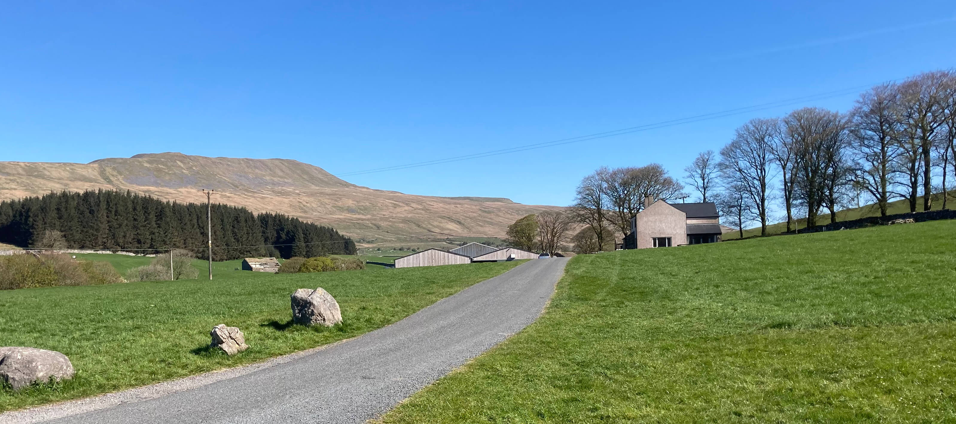
The view (shown above) towards Philpin Farm, with Whernside beyond, is an especially
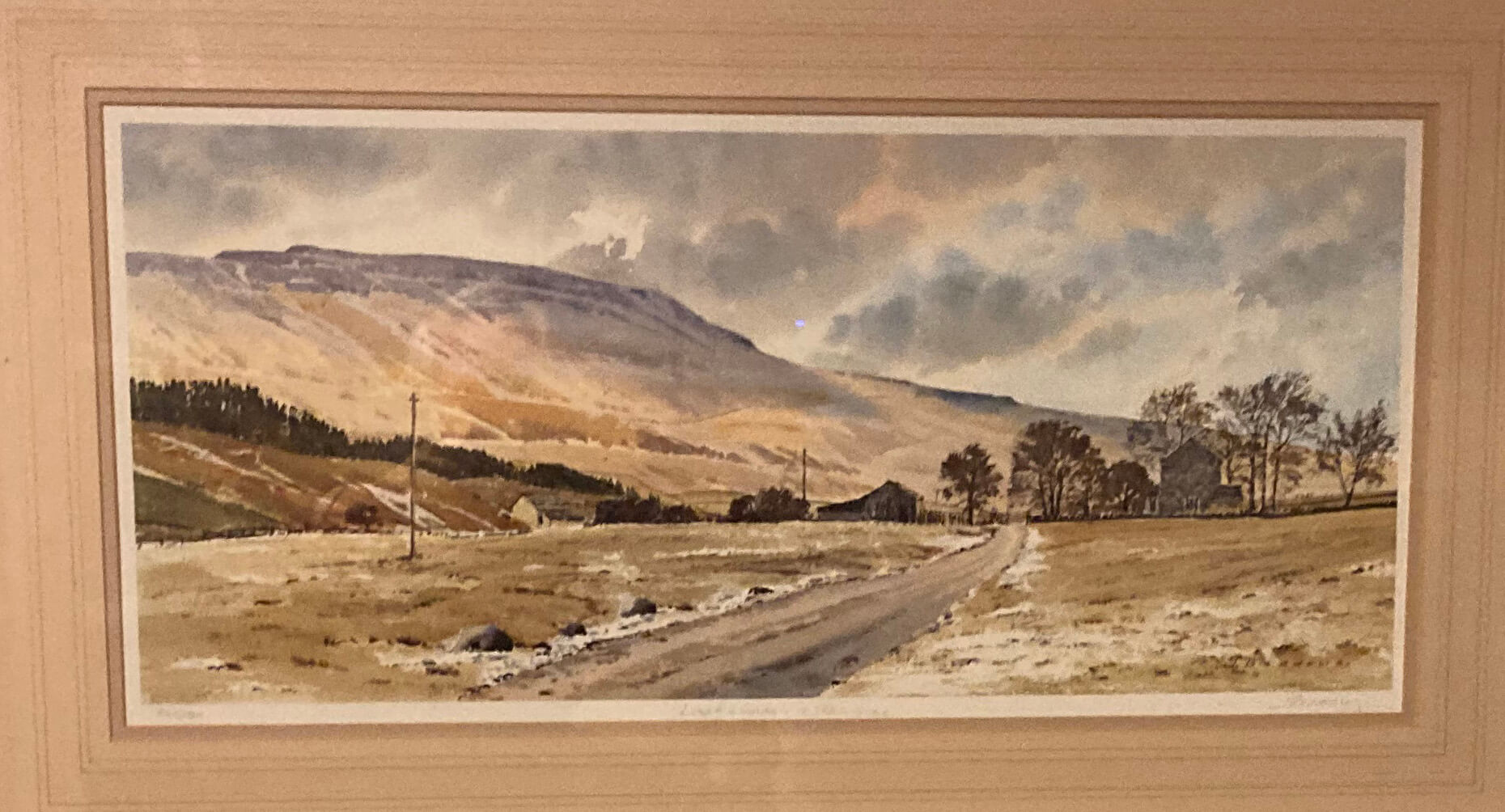
familiar one to me. The same view is portrayed in a painting that hangs on the wall
of our dining room (shown below). I like both the view and the painting of the
view – but my appreciation of the two is different.
We form an aesthetic opinion about sculptures, symphonies, streams and sycamores. But we
know that the first two are intentional objects and the last two are not. The first
two are created with the intention that we form an opinion about them. The last two
are natural objects: there is no creator of them to care whether we have an opinion about
them or not (unless you believe that a divine creator is). Our painting is in the first
set; the view itself is in the second set. Of course, a view is usually not an entirely natural object.
It has been shaped by us over the centuries, by planting trees, building sheds, adding
telegraph poles, and so on – but this shaping has not usually been carried out with
our aesthetic opinion in mind.
With intentional objects, we can’t help wondering about what the creator intended.
Some of his or her decisions are no doubt sub-conscious. For example, standing at the
spot where the easel was positioned there is a 360 degree view but the artist has focussed
us on the five degree view shown – and to emphasise that this is the focus the rest is
outside the picture frame. The painting shows a wintry scene but Whernside itself is not
under snow, so that its features can be displayed in muted colours. The conifers to the
left have grown since the painting – or perhaps the artist lowered them (as is allowed!) to
show us more of the mountain. My photograph of the view is an intentional object too
but my intention was simple – to show the actual scene (today) of the view painted.
One difference between a view and a painting of the view is that I cannot walk
through a painting. I am stuck forever with this painted view, as determined by the
artist, whereas I can walk past Philpin Farm to enjoy a varied palette of views.
The Ribblehead Viaduct can be seen to the right, while the stately profiles of Ingleborough
and Pen-y-ghent rise behind. Ahead the length of the Whernside ridge is gradually revealed.
Once, in my youth, I set myself the challenge of running up this ridge from
Twisleton to the top of Whernside, over five miles and 500 metres of ascent, without
slowing to walk anywhere. The fact that I did so shows that this ridge has no
steep or scrambly sections. A walker might find it a relentless plod but I can
recommend it for a runner.
Once past Philpin Farm the route on to Bruntscar seemed very familiar
although it must be twenty years since I’ve walked here. Then the climb up over moorland
(on part of the Three Peaks route) began. As I gradually neared the ridge I was passed
by a number of people on their way down. Every one of them commented that it was very windy up there.

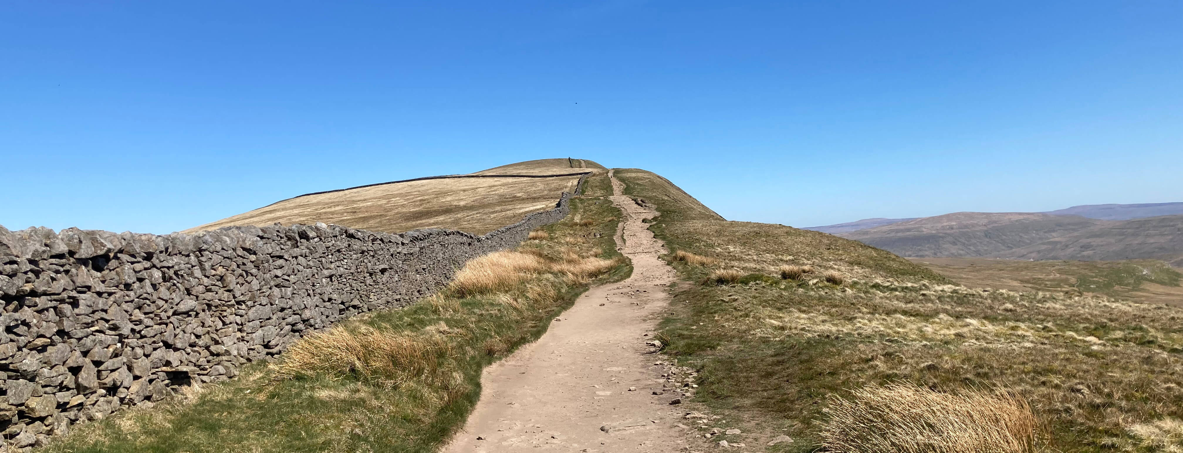
The path up (it would be difficult to lose this path)
As it happens, I had noticed the wind. It would have been hard not to. It had been calm in the
valley and I was surprised at how strong the wind had become at these higher altitudes. It
wasn’t so much the strength that was the problem: it was its boisterous, capricious nature.
One minute you’d be walking at 45 degrees battling to make progress against a head wind. The
next you’d be bowled along by a following wind. And then it would blow you off the path
to the left – and then to the right. For every step you’d aim your foot at a particular
spot – but the wind would have other ideas. It was an interesting challenge but the novelty
of it soon waned.
The walk along the ridge to the top (736 metres) was a struggle: two steps forward
and one step backward, and sometimes vice versa. Whernside is the highest of the Yorkshire
Dales hills but it lacks the appeal of the other two of the Three Peaks (Ingleborough and
Pen-y-ghent). It doesn’t have an impressive shape from any direction – the only direction
that gives it a profile different from a great, swelling hump is from the north, from Baugh Fell, say.
I can imagine someone writing a poem about Ingleborough or Pen-y-ghent but not about
Whernside.
The path to the top of Whernside
I stepped through the gap to the trig point, which is on the other side of the wall, and felt
a new sensation: I was standing on grass. I do believe that I had walked the whole way up
Whernside without stepping on a single blade of grass (except
when I was blown off the path). After the lane to Bruntscar, the
path has been reinforced with great slabs and where it hasn’t the path has been worn down to rock and soil.
I thought I’d walk a bit on the grass so I headed towards the Whernside Tarns that lie
about a mile north. Halfway there I changed my mind. It wasn’t much fun being buffeted
side-to-side, trying to make sure that nothing blew away in the wind, and, of course, it was
all more tiring. I did try to stand still long enough to appreciate the views, of green
Dentdale with the Howgills beyond, of the other two Peaks, and of more distant Lakes and Dales
hills. The Whernside Tarns (there are three of them) are not that exciting. The main point
of interest is that they are here at all. Like Ingleborough, Whernside is not limestone
all the way up. The tarns, including Greensett Tarn to the east of the top, lie at the
transition to millstone grit.
When I had set off I had half-a-plan to make a loop of it by dropping down to the
Ribblehead Viaduct. Nowadays, however, I prefer my walks to be somewhat relaxing and not
a battle against nature. So I turned to walk back the way I came: at least I knew what to
expect that way. It was a slow, careful descent. I was blown over onto my bottom only
two or three times.
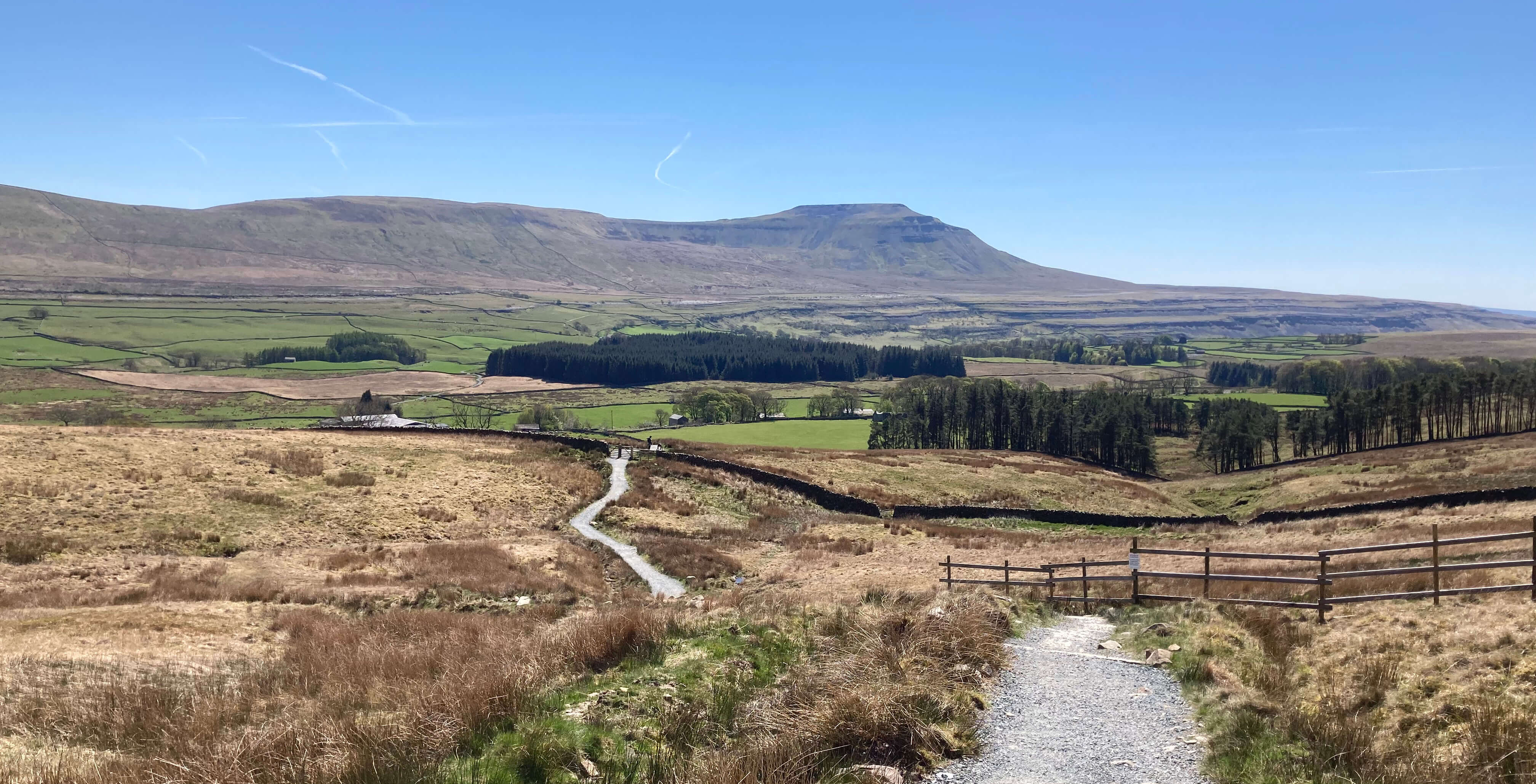
On the way down from Whernside, with Ingleborough ahead

A look back to Whernside (and I could no longer say
that there's not a cloud in the sky)
It was an invigorating outing with plenty of fresh air (more than I needed really) but perhaps
the time will come soon when I will prefer to look at a painting of a
view rather than the view itself.
Date: April 29th 2026
Start: SD746778, lay-by NE of Hill Inn (Map: OL2)
Route: SW – Philpin Lane
– N – Bruntscar, Whernside, 1 km past the top – S back the same way
Distance: 7 miles; Ascent: 440 metres
Home
Preamble
Index
Areas
Dales
Hills
Lakes
Places
Reserves
Rivers
Structures
Villages
References
Me
© John Self, 2018-

Top photo: Rainbow over Kisdon in Swaledale;
Bottom photo: Ullswater