
Home
Preamble
Index
Areas
Dales
Hills
Lakes
Places
Reserves
Rivers
Structures
Villages
References
Me
Saunterings: Walking in North-West England
Saunterings is a set of reflections based upon walks around the counties of Cumbria, Lancashire and
North Yorkshire in North-West England
(as defined in the Preamble).
Here is a list of all Saunterings so far.
If you'd like to give a comment, correction or update (all are very welcome) or to
be notified by email when a new item is posted - please send an email to johnselfdrakkar@gmail.com.
233. A Rivetting Tale of High Gimmerdale
 Wray is a village best seen in the imagination. Look along Main Street from the north
end and imagine that there are no parked cars. Then the buildings either side – the cottages,
the pub, the farm, the village hall, the church, the shop – will be seen to be well
separated with neat cobbled areas in front. If your imagination is up to it, you might
picture the scene in past centuries – perhaps with a horse and cart or two, children
playing, women chatting, dogs asleep, and so on. That is how Wray was designed to be,
for Wray (which is not mentioned in the Domesday Book) is thought to have been created
in the 13th century by the Lord of Hornby for his workers.
Wray is a village best seen in the imagination. Look along Main Street from the north
end and imagine that there are no parked cars. Then the buildings either side – the cottages,
the pub, the farm, the village hall, the church, the shop – will be seen to be well
separated with neat cobbled areas in front. If your imagination is up to it, you might
picture the scene in past centuries – perhaps with a horse and cart or two, children
playing, women chatting, dogs asleep, and so on. That is how Wray was designed to be,
for Wray (which is not mentioned in the Domesday Book) is thought to have been created
in the 13th century by the Lord of Hornby for his workers.
I walked along Main Street and turned up School Lane, passing the primary school where
a sign says that it “is the gift of Captain Richard Pooley of Wray”. Captain Pooley
apparently flourished in the Civil War, sufficiently to endow this school in 1684. There
are also two plaques on the wall commemorating noted alumni, Bryan Holme (who founded the
Law Society) and Archie Kenyon (a journalist). So the school clearly teaches its pupils
what is right and how to write.
It was a sunny, still, silent, early autumn day. The hawthorns were full of their
red berries and the rose-hips glowed red-orange. Sheep and cows stood contentedly in the fields,
no doubt relishing the sunshine after days of heavy showers. As the lane climbed up to
the Roeburndale moors views opened out, especially of the Yorkshire Dales hills. They were
not crystal clear but even so they provided a fine panorama.

The first view of Whernside, Ingleborough and Pen-y-ghent from School Lane
After a mile or more, School Lane joins Moor Lane, which rises from Hornby, and reaches the
cattle grid at the open moor. This road features prominently in a book I was recently
given: Crook o’ Lune: A Lancashire Mystery written by E.C.R. Lorac and published in 1953.
I had never heard of the book or the author. How had my painstaking research into my local
dale, Lunesdale, missed such a literary gem? At least, I assume that it is a literary gem
since it has recently been republished as a British Library Crime Classic.

 It turns out that E.C.R. Lorac was the principal pen-name of Edith Caroline
Rivett (1894-1958), who was born in London and moved to live in the village of Aughton
(pronounced Affton) in the Lune valley for the last fifteen years or so of her life. I understand
that her Aughton home has recently been blue-plaqued. She fair rattled out her novels,
writing 76 of them in 28 years. Some of the later ones are based in Lunesdale,
including Crook o’ Lune.
It turns out that E.C.R. Lorac was the principal pen-name of Edith Caroline
Rivett (1894-1958), who was born in London and moved to live in the village of Aughton
(pronounced Affton) in the Lune valley for the last fifteen years or so of her life. I understand
that her Aughton home has recently been blue-plaqued. She fair rattled out her novels,
writing 76 of them in 28 years. Some of the later ones are based in Lunesdale,
including Crook o’ Lune.
I am not sure of the correct way to refer to her today. She was E.C.R. Lorac to her
readers, of which there must have been many since the publishers were so happy. From the ‘Lorac’,
I’d guess that she was Carol Rivett to family and friends. Perhaps she used E.C.R. Lorac
because, like many women authors of the time, she felt there was a bias among publishers
and readers against women (although ‘Agatha Christie’ didn’t do her any harm). If she
were writing today then she’d probably use Carol Rivett and we would refer to her by surname,
as we do for male authors. However, ‘Rivett’ sounds rather abrupt to me. Obviously,
Ms Rivett won’t do, as it unnecessarily draws attention to her spinsterhood. So Rivett it is.
The action in Crook o’ Lune occurs in Gimmerdale (which is Roeburndale re-named) to
the south of the village of Kirkholm (Hornby re-named). Peripheral place-names, such as
Gressingham, Caton, Slaidburn, the Forest of Bowland and the Lune, retain their real names.
The few scattered buildings in Gimmerdale are re-named and re-positioned from those in
Roeburndale so that nobody will be led to believe that dastardly deeds occurred at a
particular real place. Most of the invented names for people and places are derived
from sheep-farming – Ramsden, Tupper, Lambsrigg, Shearling, Ramshead Pike, Herdwick and
so on – which, I suppose, helps to give an authentic air to the tale.
Much of this will be lost on most readers, who will read the book as a novel
based on some fictional northern moor. For me, however, it is a strange experience to read
Crook o’ Lune because I can’t help relating the narrative to the real Roeburndale,
as her incidental descriptions of Gimmerdale are quite evocative of the region. Rivett
clearly knew a great deal about sheep-farming or, rather, had a friend to advise her. With
all that writing, she hardly had time for sheep-farming herself. She also captured the
nature of the tough life in these isolated farmsteads, where there is a certain kind
of community spirit with family memories going back centuries.
There is a lot of walking in Crook o’ Lune. People walked up the steep lane
(Moor Lane) from Kirkholm to High Gimmerdale, and between the various farmsteads, and on
the open moor above the highest farms. Cars travelled up too but there weren’t many of
them in the 1950s and they struggled with the steepness. I used to run up these roads
and my engine certainly struggled.

The view of the Yorkshire Dales from the highest point of Moor Lane
Rivett describes this road much as it is today, with its cattle grids, a levelling
off with views across to the Yorkshire Dales and a steep drop down to a bridge (where
Barkin Bridge is today). Up from the bridge we today pass Lower Salter and Rivett
has here a church and a no-longer-used endowed school. There is actually a small
Methodist church here but I doubt that there was ever a school. However, farmers’ children
needed some schooling and daily treks to and from Kirkholm would not have been easy,
so some informal schooling probably occurred here. The school that Rivett describes
seems to be modelled on the one in Wray.
Rivett has the road continuing up (as it does today past Middle Salter and High Salter)
before becoming a rough track. This is the Hornby Road (or Old Salt Road) that I described in
[156]. This track plays a key role in the story. Several sheep go
missing, presumed stolen, from the high fells. It seems unlikely that sheep-stealers could
drive up this difficult road to its end, herd sheep from the fell, and gather them into a
vehicle all without being seen or heard (especially by the dogs – they always notice me).
Therefore, it is surmised that sheep-stealers must have walked up the Old Salt Road from
the other direction, that is, from Slaidburn, and taken the sheep back over the watershed.
Unfortunately, I know that there is a side-road just beyond Lower Salter that crosses
the River Roeburn and continues west into Littledale. The sheep-stealers could have used
that. Perhaps it wasn’t a surfaced road in 1953? Today it is sort-of-surfaced to
and from Haylot Farm but the OS doesn’t mark this as a road (perhaps to discourage
visitors from tackling it), and it is hardly one usable by a vehicle to steal sheep. But
Crook o’ Lune is a novel and I mustn’t quibble about details. Rivett needs
Gimmerdale to be a secretive, enclosed dead-end.
Here, then, I departed from Rivett and her imagination and took the side-road
down to the River Roeburn. Here there used to be an ‘Irish bridge’, which was really a
ford with two small pipes under it. After heavy rain, the river flowed over the ford (and
after really heavy rain it would be impassable). Recently, the Irish bridge has been
replaced by a more normal bridge, with plenty of space under it for the river – and for
migrating fish. Previously, it seemed unlikely that fish could even reach the pipes,
let alone swim through them. Unfortunately, there has not been (as far as I am aware)
any follow-up study (as is sadly the case with many such projects) to determine whether
there are now more fish up-river.
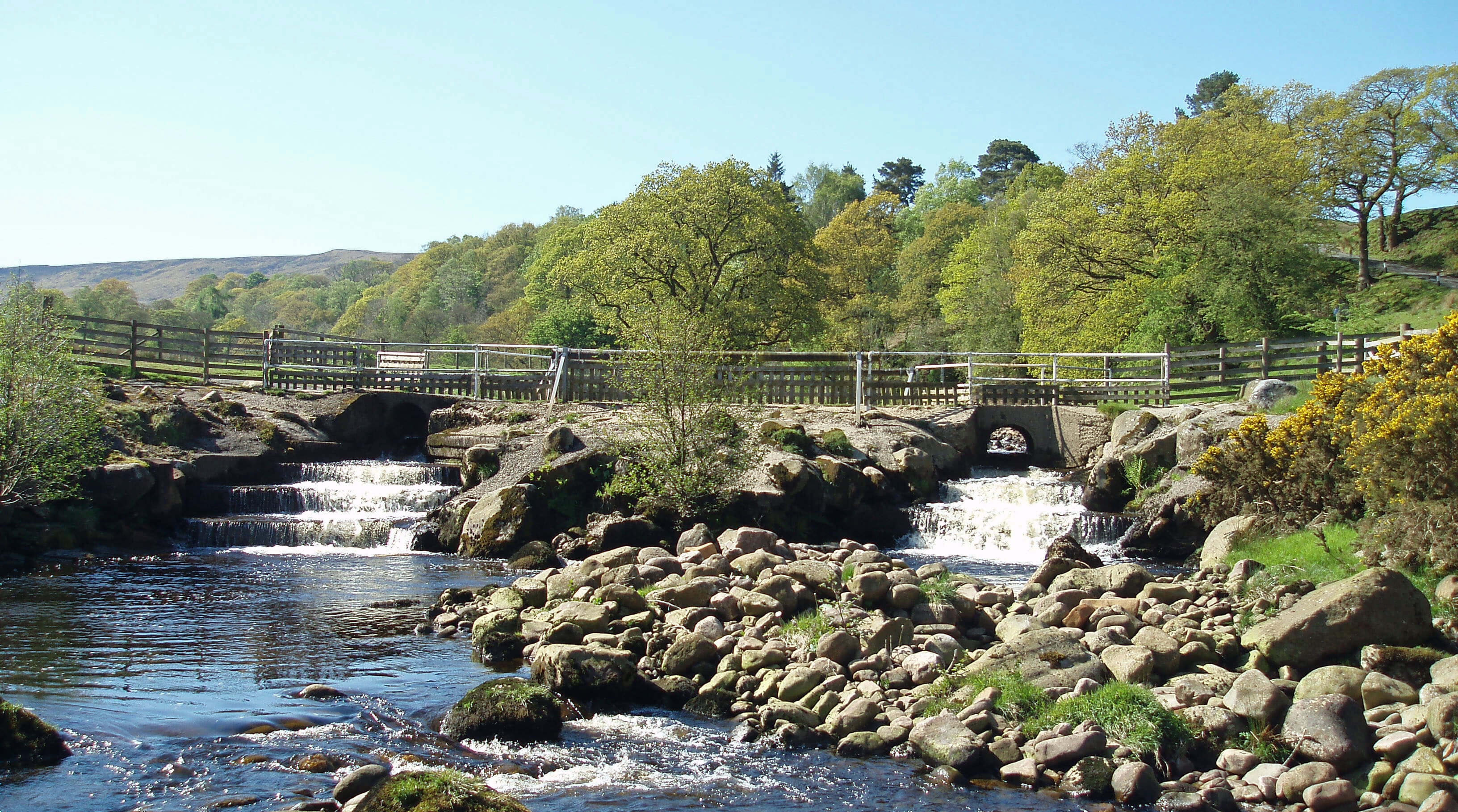

Left: The old 'Irish bridge'; Right: The new bridge.
From Haylot Farm I dropped down to cross Bladder Stone Beck. What an implausible name! I think
that what happened here is that some young surveyor was sent up from London to ask locals
for the names of landscape features and our farmer would have been exasperated by all
these questions when he had sheep to tend to and just said “Tha’s bloody Stone Beck”.

Dropping down to Bladder Stone Beck from Haylot Farm, the farm of Winder ahead
The Roeburndale Road west is very familiar to me but I always enjoying travelling along
it because it gradually reveals wide-ranging views ahead within which I can see my home
village and dale in context. At first, we see Morecambe Bay, with Heysham Power Station
prominent, and on this occasion the Isle of Man ferry stationary in the bay, for some reason.
Fleetwood and Blackpool were somewhat indistinct, but the Lake District hills gradually came
into view, first Black Combe, then Coniston Old Man, and so on.

The distant view of Lake District hills from the Roeburndale Road,
with, in the near distance, the villages of Halton and Caton in Lunesdale
Nearer lay the villages of Halton, Caton and Brookhouse and the green Lune valley,
within which lies the Crook o’ Lune. Thinking again of the recently-rediscovered
Rivett, I wonder if she will be recognised as a lost literary lioness of Lunesdale.
She clearly had a successful career, churning out her mysteries, but they were soon
forgotten after her death in 1958. Today she is apparently the best-selling author
on the British Library Crime Classics list although I don’t know how much of an
achievement that is since I’ve never heard of any of the other authors on the list
either.
And so I continued the long walk down, passing what we call the ‘bluebell
wood’, where I was saddened to see that many of the fine old beech trees had been
chopped off half way up. Perhaps there was a good reason. As I dropped down I
kept my eye on the distant hills as they gradually disappeared behind the northern ridge of the
Lune valley, where the village of Aughton lies. The last to disappear was Black
Combe, leaving me with just a few minutes more to reach home.
Date: September 23rd 2025
Start: SD602677, Hornby Road bus-stop, Wray (Map: OL41)
Route: (linear) SE on Main Street – School Lane – SW, S – Moor
Lane – S – Barkin Bridge – S past Lower Salter – River Roeburn – S – Haylot Farm – NW – road
near Winder – SW, W – cattle grid – W on Roeburndale Road past Roeburn Glade – Littledale
Road – NW, N – Brookhouse
Distance: 9 miles; Ascent: 380 metres
Home
Preamble
Index
Areas
Dales
Hills
Lakes
Places
Reserves
Rivers
Structures
Villages
References
Me
© John Self, 2018-

Top photo: Rainbow over Kisdon in Swaledale;
Bottom photo: Ullswater