Home
Preamble
Index
Areas
Dales
Hills
Lakes
Places
Reserves
Rivers
Structures
Villages
References
Me
Saunterings: Walking in North-West England
Saunterings is a set of reflections based upon walks around the counties of Cumbria, Lancashire and
North Yorkshire in North-West England
(as defined in the Preamble).
Here is a list of all Saunterings so far.
If you'd like to give a comment, correction or update (all are very welcome) or to
be notified by email when a new item is posted - please send an email to johnselfdrakkar@gmail.com.
12. Blea Water, High Street and Kidsty Pike
It is a fine Lakeland walk from Mardale Head to High Street but it starts with a tone of melancholy. A noticeboard
reminds us that the village of Mardale Green, with houses, church and pub, was submerged when the Haweswater
Reservoir was constructed. However, that sad event – sad to the ex-residents of Mardale Green anyway – happened
in 1935, so it would be a very elderly walker who had personal memories of it today.
A second notice advises those who have come to see the eagles that they are too late. The eagles have
gone – which is indeed rather sad. Palmer (1930)
said that “Martindale was the last nesting haunt of the golden eagle south of the Border. About eighty years ago
the last bird was shot, and there has been no resettlement.” However, about a hundred years after that eagle was
shot – that is, in the 1950s – golden eagles began to be seen again in the Lake District. In 1969 a pair managed
to breed in Riggindale, below High Street. Since then the nest had been sustained by a series of male and female
eagles, producing sixteen young. Unfortunately, after 2004 the returning male eagle was unable to attract a mate.
Even more unfortunately, he has not been seen since 2015 and is presumed to have died.
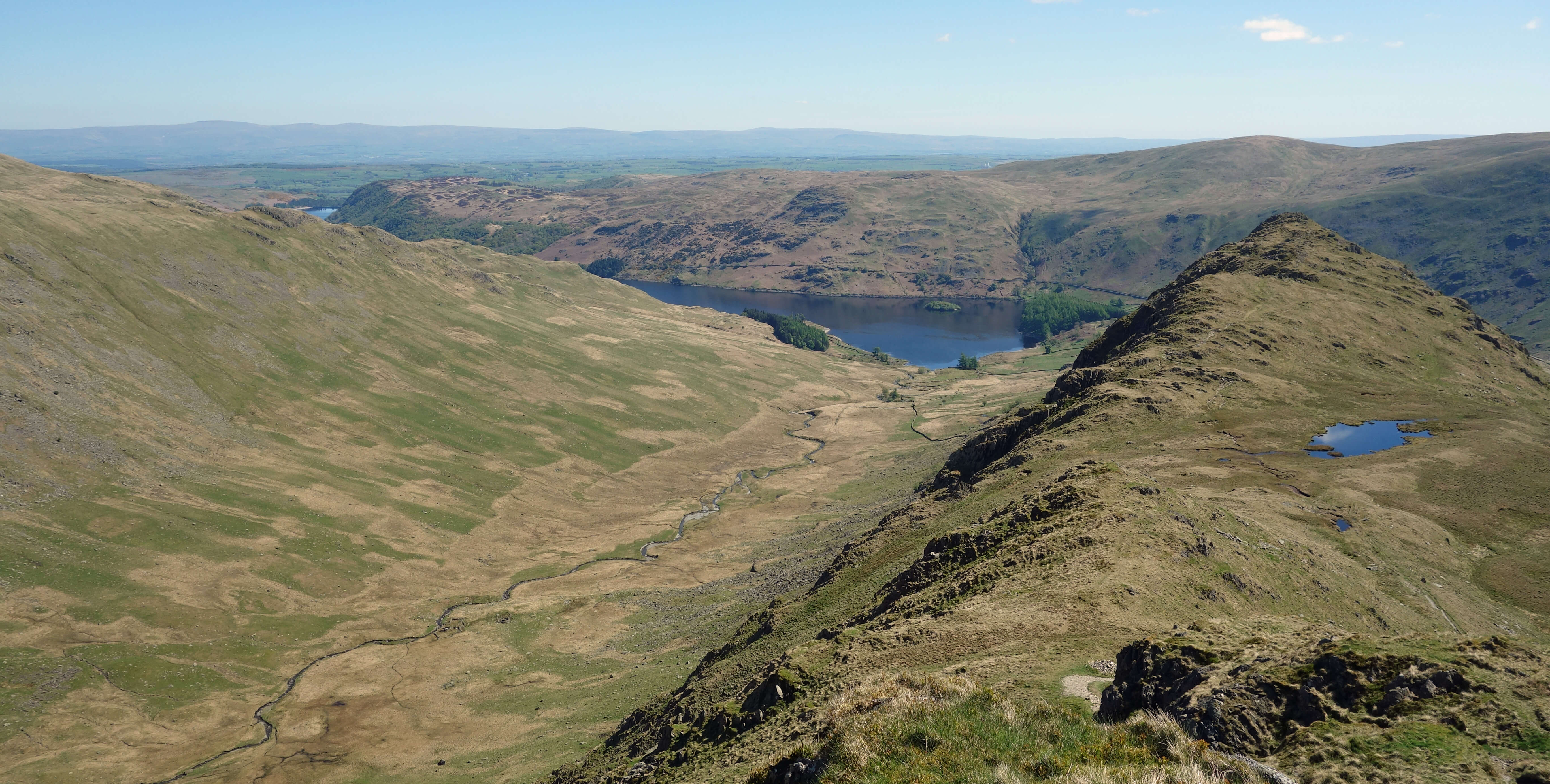
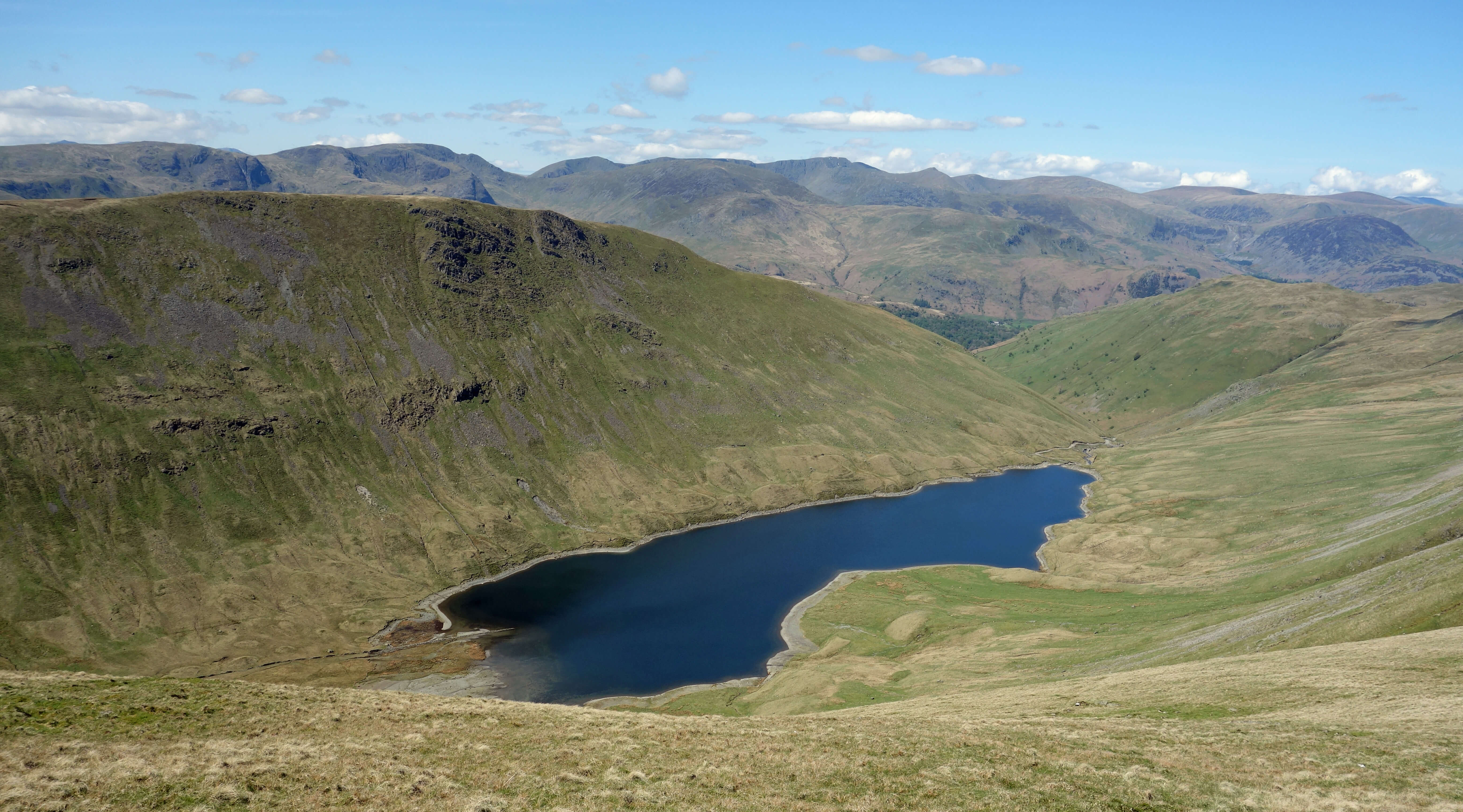
Riggindale and Haweswater from Long Stile
The chances of golden eagles returning again to the Lake District are not high at the moment. Although
there are about 500 pairs of golden eagles in Scotland only a very few of those breed south of Glasgow. There is a
programme
to increase the numbers of golden eagles in southern Scotland by re-introducing up to ten eagles a year in the Moffat hills.
It is hoped that some of the eagles will be able to run the gauntlet of moors for grouse-shooting in the Scottish borders and
English uplands and drift south to establish territories in northern England. However, experts apparently consider
that there is a shortage of suitable terrain and food – but eagles did manage for decades in Riggindale, which
seems similar to several other dales to me. Anyway, for now, walkers will look wistfully and forlornly around
the Riggindale crags and in the skies above in search of a golden eagle.
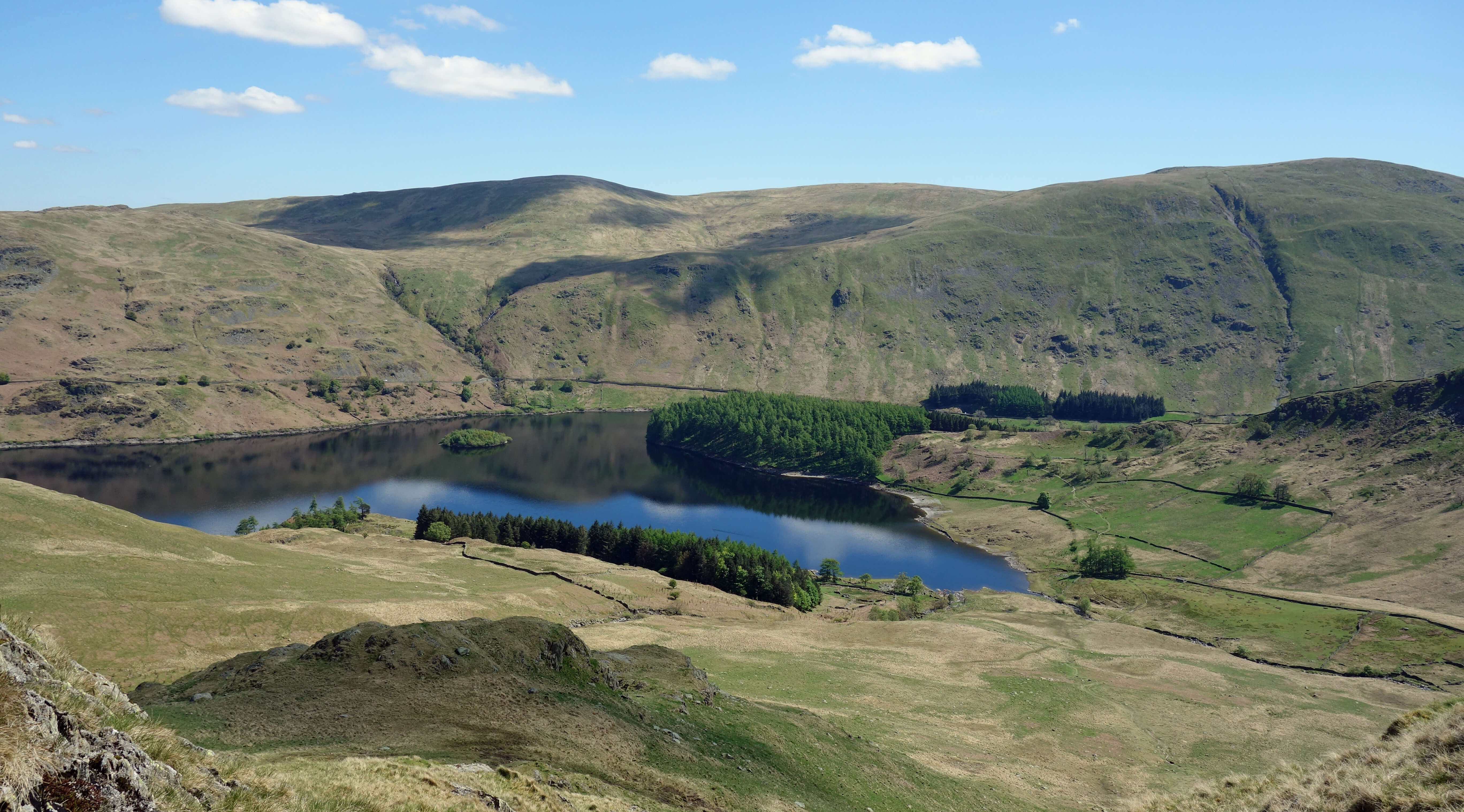
Enough negativity. There is plenty still to be enjoyed on this walk. We walked up to Blea Water, to see
it at close quarters for the first time (previously we had only peered down at it from the heights of Mardale Ill
Bell and High Street). On the way we passed many recently-planted trees, a welcome attempt to return some of the
over-sheep-grazed grass and bracken slopes to a more natural habitat.
Blea Water is one of the finest of Lakeland
tarns, enclosed on three sides by the steep cliffs of Blea Water Crag, High Street and Riggindale Crag. It is said
to be 61 metres deep – and I could well believe it – which is deeper than all the Lake District lakes except Wastwater and
Windermere. We met a team from United Utilities who were contemplating removing the small dam, which serves no
function and is a bit of an eyesore. The word ‘blea’, incidentally, comes from an Old English word meaning blue or
dark, which I suppose Blea Water is, but it was also sparkling like a dewdrop in fresh May sunshine.

Blea Water from Long Stile
We clambered up the Long Stile ridge to High Street (828 metres), which is by far the best way to approach it. High Street
itself is, let’s be honest, a little dull, unless you have a vivid imagination and can see Romans marching along their
road or horses galloping on Racecourse Hill. But emerging from Long Stile you suddenly see a wide panorama of all the
great Lakeland peaks: from left to right, Coniston Old Man, Crinkle Crags, Bowfell, Scafell Pike, Great Gable, Fairfield,
Helvellyn, Skiddaw, Blencathra. Only the High Street range presents all the classic peaks ahead of you. Admittedly,
they are a little distant but they have to be in order to fit them all in. It is inspirational to see them all arrayed
ahead, especially on a clear day such as this was. I can hardly wait to visit them again during the course of these
Saunterings.
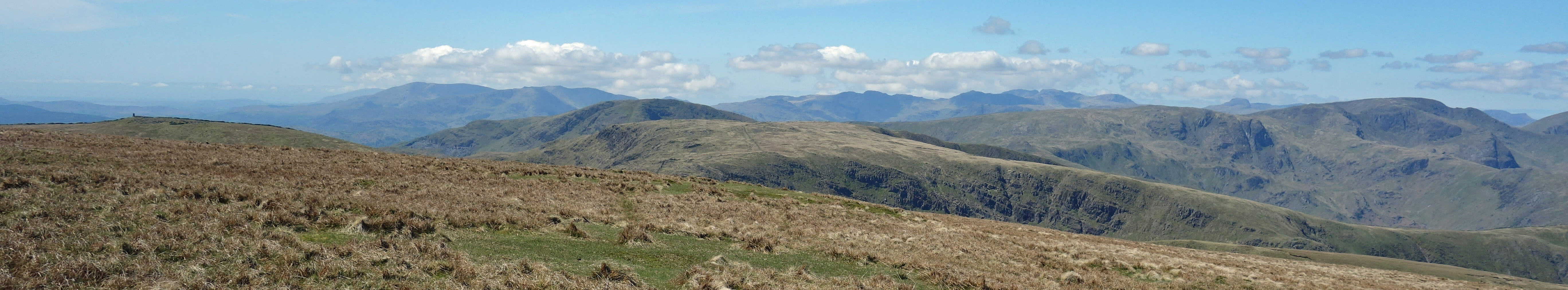
From High Street (south-west): Coniston Old Man, Crinkle Crags, Bowfell,
Scafell Pike, Great Gable, Fairfield
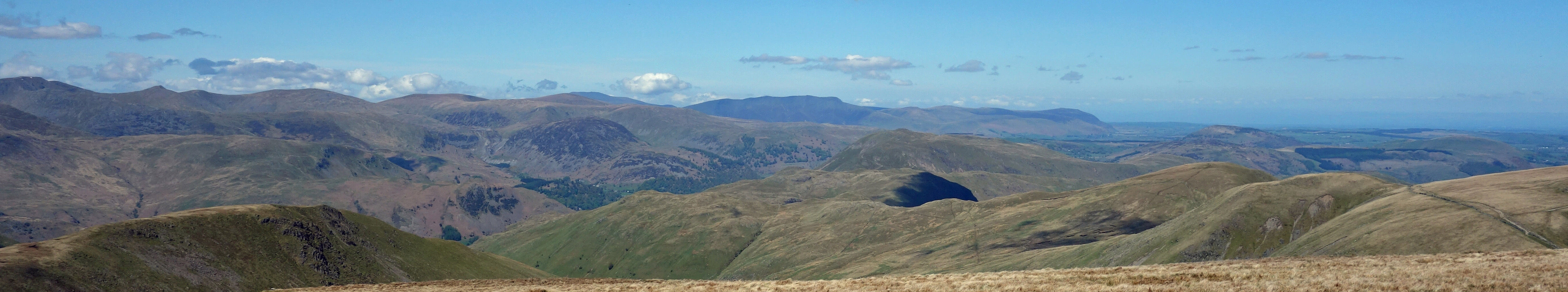
From High Street (north-west): Helvellyn, Raise, Skiddaw, Blencathra
Left: Hayeswater from High Street (note the bare rim around
Hayeswater which comes from United Utilities removing its dam and thereby lowering
its surface by a metre or two);
Right: Haweswater from the path down from
Kidsty Pike.
We admired the view for some time before setting off down past Kidsty Pike (780 metres).
The view from Kidsty Pike suffers by
comparison with the High Street view. Kidsty Pike is the prominent pointed peak seen from the M6 and you would
expect that, in consequence, it provided a good view to the east – and indeed it does, of the Cross Fell Pennines,
the Shap Fells, the Howgills and some of the Yorkshire Dales peaks. These too are all within my Saunterings scope! And on the
walk down and at closer quarters there’s a fine prospect of Haweswater.
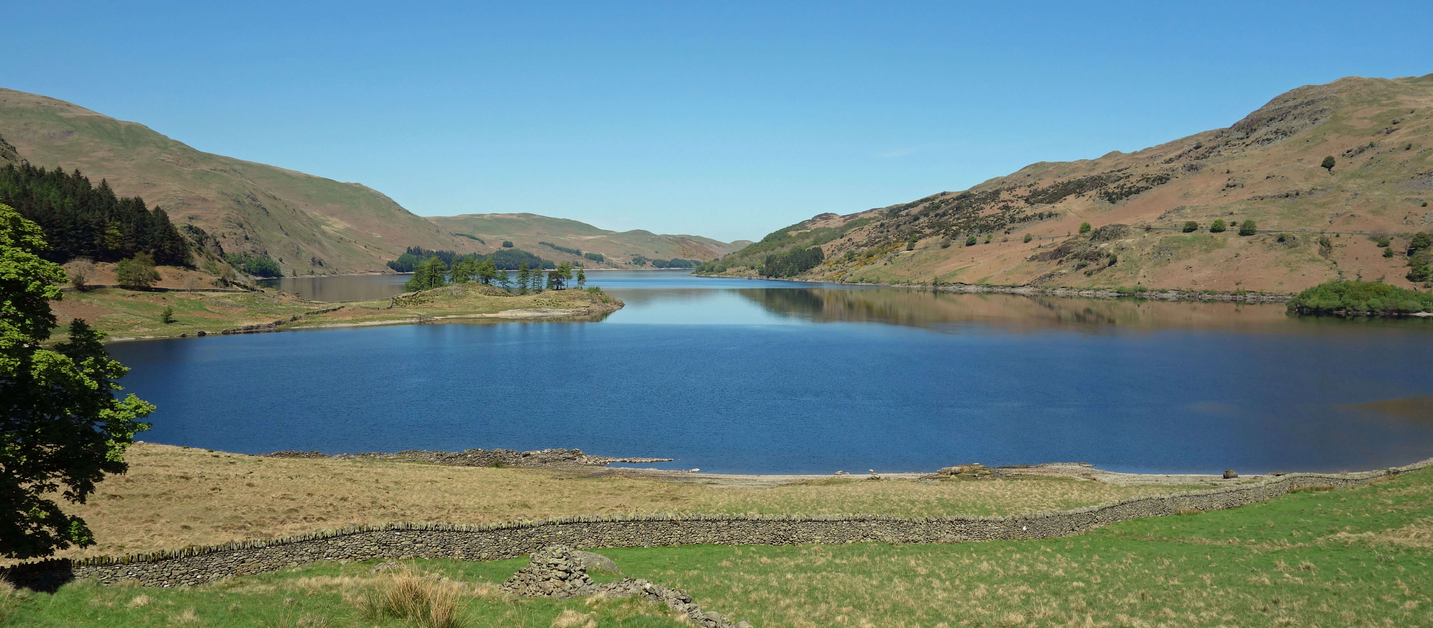
Haweswater
Back at the car park we met the United Utilities team again. I hope I’m not giving away any company plans
by saying that the main problem they foresaw in removing the dam was getting rid of all the concrete. They reckoned
it’d take a hundred helicopter trips to lift it all out! Quite why United Utilities would pay to do this I don’t
know but I hope that they do return Blea Water to its natural state. I am sure that they won’t be tempted to just
tip all the concrete into the depths of Blea Water. It would hardly be in a natural state then, would it?
Date: May 14th 2018
Start: NY469107, Mardale Head (Map: OL5)
Route: W – Blea Water – NW – Long Stile – W – High Street – N – Straits of
Riggindale – E – Kidsty Pike, Kidsty Howes – S – Mardale Head
Distance: 7 miles; Ascent: 590 metres
Home
Preamble
Index
Areas
Dales
Hills
Lakes
Places
Reserves
Rivers
Structures
Villages
References
Me
© John Self, 2018-
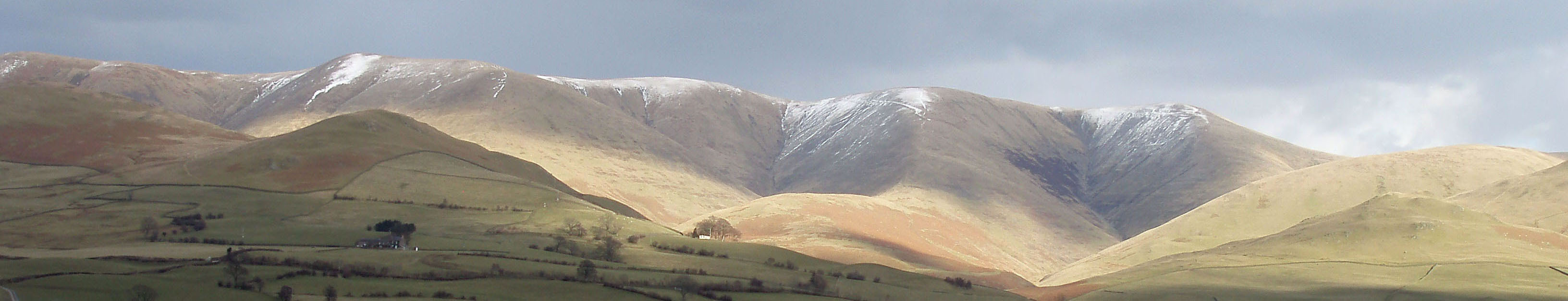
Top photo: The western Howgills from Dillicar;
Bottom photo: Blencathra from Great Mell Fell