Home
  Preamble
  Index
  Areas
  Map
  References
  Top10s
  Me
  Drakkar
Saunterings 91-100
Saunterings is a set of reflections based upon walks around the counties of Cumbria, Lancashire and
North Yorkshire in North-West England
(more details of my ‘North-West England’ are given in the Preamble).
If you'd like to give a comment, correction or update (all are very welcome) or to
be notified of new items as they appear - please send an email to johnselfdrakkar@gmail.com.
Some readers' comments are included in the Preamble.
     Latest (with a list of all Saunterings so far)
     Next 101 - 110
     100.   Crookdale and Horseshoes
     99.   Heather on Hawthornthwaite Fell
     98.   Karren and Flora on Hutton Roof Crags
     97.   Remeandering the Lyvennet
     96.   Castles and Towers from the Cross of Greet
     95.   Barbondale and the Dent Fault
     79-94 are about walks from home during the coronavirus lockdown.
     94.   Away from It All on Caton Moor
     93.   The Brookhouse - Claughton Circular
     92.   The Small-Leaved Limes of Aughton Woods
     91.   The Littledale Cuckoos are Back!
     1 - 90
100.  Crookdale and Horseshoes
Horseshoes are said to bring good luck, so I thought I’d try one. Hill-walkers are particularly fond of horseshoe walks, that is, walks out on one ridge of a dale, across the head of the dale, and back along the opposite ridge. There is something satisfying about a walk that fully embraces a dale, enabling it to be viewed from all angles. It is good to be able to see across the dale to where you will be walking later and, later, to see back across to where you were walking before.
In his comprehensive review of Lakeland fells, Birkett (1994) includes 21 horseshoe walks among his 129 walks up 541 tops. He names his Horseshoes:
   •   Bannerdale   (7 miles over East Top, Bowscale Fell, Bannerdale Crags, Souther Fell)
   •   Bannisdale   (8 miles over Whiteside Pike, Todd Fell, Capplebarrow, Ancrow Brow, Long Crag, White Howe, Borrowdale Head, Lamb Pasture)
   •   Buttermere   (6 miles over Fleetwith Pike, Black Star, Grey Knotts, Brandreth, Haystacks)
   •   Calder   (8 miles over Blakeley Raise, Grike, Crag Fell, Whoap, Lank Rigg, Kinniside, Latter Barrow, Swarth Fell, Burn Edge)
   •   Cawdale   (9 miles over Low Kop, Red Crag, Wether Hill, Loadpot Hill)
   •   Combe Gill   (5 miles over Thornythwaite Fell, Combe Head, Stonethwaite Fell, Rosthwaite Cam, Bessyboot)
   •   Crookdale   (7 miles over High House Bank, Robin Hood, Lord’s Seat, Great Yarlside, Little Yarlside, What Shaw)
   •   Dale Head   (10 miles over Skelgill Bank, Catbells, Maiden Moor, High Spy, Dale Head, Hindscarth, High Crags, Red Knott, Scope End)
   •   Deepdale   (10 miles over Arnison Crag, Birks, Gavel Pike, St Sunday Crag, Cofa Pike, Fairfield, Hart Crag, Gill Crag, Gale Crag)
   •   Fairfield   (10 miles over Low Pike, High Pike, Dove Crag, Hart Crag, Fairfield, Great Rigg, Rydal Fell, Heron Pike, Nab Scar)
   •   Hartsop   (6 miles over Hartsop Dodd, Stony Cove Pike, Gray Crag)
   •   Helm Crag to Steel Fell   (7 miles over Helm Crag, Gibson Knott, Calf Crag, Dead Pike)
   •   Hesk Fell   (6 miles over The Pike, Hesk Fell, Yoadcastle, Stainton Pike, Whitfell, Bigert)
   •   Hope Gill   (6 miles over Dodd, Whiteside (East, West), Gasgale Crags, Hopegill Head, Sand Hill, Ladysike Pike, Swinside)
   •   Kentmere   (12 miles over Shipman Knotts, Goat Scar, Kentmere Pike, Harter Fell, Mardale Ill Bell, Thornthwaite Beacon, Froswick, Ill Bell, Yoke)
   •   Martindale’s Bannerdale   (9 miles over Beda Head, Angletarn Pike (North, South), Brock Crags, Rest Dodd, The Nab)
   •   Mosedale   (7 miles over Looking Stead, Pillar, Black Crag, Scoat Fell, Steeple, Red Pike)
   •   Naddle   (7 miles over Scalebarrow Knott, Harper Hills, Powley’s Hill, Hare Shaw, Naddle High Forest, Wallow Crag, Naddle Low Forest)
   •   Riggindale   (7 miles over Rough Crag, High Street, Rampsgill Head, Kidsty Pike)
   •   Robinson   (7 miles over Scope End, Red Knott, High Crags, Hindscarth, Robinson)
   •   Wetherlam and the Greenburn   (9 miles over Birk Fell, Wetherlam, Black Sails, Swirl How, Great Carrs, Little Carrs)
It is easily possible to add further horseshoes – for example, Dovedale, Eskdale, Grisedale and Scandale are all fairly well-known horseshoes – and, of course, horseshoes are not restricted to the Lake District.
I opted for the most remote and the least craggy of Birkett’s 21 horseshoes, that is, the Crookdale Horseshoe. This is within
the Shap Fells, the wide area of moorland south of Shap and west of the A6. I first walked under a double line of tall pylons marching across
the moor, next to a rough track that, hard to believe now, was the main thoroughfare before the A6 was built and where Bonnie Prince Charlie
marched his Jacobites. I forded Crookdale Beck and scrambled up the slopes of High House Bank (495 metres, which may seem an impressive
height – but the car park was at 426 metres, although to do myself justice I had dropped down a fair way to the beck). This scramble was
the only steep climb of the whole walk. Once the ridge was attained, it was a matter of striding out (as far as that was possible over
the boggy bits) over the various humps along the way. From this southern ridge of the horseshoe the view south into upper Borrowdale and across to
Bannisdale Fell was rather better than that into the featureless, grassy Crookdale.
Upper Borrowdale from High House Bank (and is that Kidsty Pike?)
After an hour or so I reached Lord’s Seat (524 metres). It is clear from Lord's Seat, and from the map, that the top of Harrop Pike (637 metres),
over a mile ahead, marks the head of Crookdale. The headwaters of Crookdale Beck run directly from it. However, Birkett considers that “rocky knolls and peat hag do not allow it to be easily reached” from Lord’s Seat and instead directs the walker to traverse over Crookdale Beck and up to the northern ridge. What sort of horseshoe is that? It omits the climax, the very apogee, the zenith of the real horseshoe, its highest point and grandest view.
Wainwright (1974) also describes a Crookdale Horseshoe but his version is even worse. He directs walkers away from Harrop Pike and the whole northern ridge! Instead, walkers are to forego the views from the ridge and trudge within the dreary, damp, enclosed dale, on the bank of Crookdale Beck. I expect that Wainwright had a good giggle at the thought of his devoted followers, without a mind of their own, dutifully traipsing into this morass. He did at least give fair warning, writing of the “drab monotony … of the marshy valley floor, of which in a lifetime one experience is enough”. The reason that both Birkett and Wainwright do not describe a proper Crookdale Horseshoe is that their omitted tops are visited on others of their walks. Such considerations will not sully the purity of my horseshoe.
So, I set off for Harrop Pike. The bee-line for Harrop Pike, over the rocky knolls and peat hag that deterred Birkett, is not the way to
go. The true horseshoer must follow the watershed, although admittedly it isn’t really a ridge here. This passes Red Crag to the west, and as
it happens a sort-of-path can be picked up beyond Lord’s Seat to take us past Red Crag and up to a fence which may then be followed
all the way to the top. This is straightforward and avoids the worst of the peat hag. Harrop Pike is not high enough to provide much of a view of the central Lake District fells – in fact, there are only such tantalising glimpses of them along the whole southern ridge that it’s hardly worth the trouble of trying to identify them. However, from Harrop Pike to the east there are excellent views of the expanses of the northern Shap Fells and in the distance of the Howgills and northern Pennines.
Harrop Pike (and is that The Old Man of Coniston?)
Nobody with the heart, soul and spirit of a fell-walker will have read the list of horseshoes above without mentally ticking off those already walked and maybe setting the target of walking some or all of the others. Fell-walkers can’t help bagging items on a list, so why not horseshoes? If, however, we are to invent such a thing as horseshoe-bagging then we need to be precise about our horseshoes. We have already seen that to qualify a horseshoe has to include the head of the dale and both ridges.
A systematic naming system would be welcome too. The identifying factor for a horseshoe is the dale or watercourse enclosed, not a peak that happens to be passed on the way. The Fairfield Horseshoe – the most well-known and most walked horseshoe – should really be called the Rydal Horseshoe because it is around Rydal Beck. It is perfectly possible to have another horseshoe that includes Fairfield and indeed there is one on Birkett’s list – the Deepdale Horseshoe. This has an equal right to be called the Fairfield Horseshoe, although that would, of course, be confusing.
Consider the Blencathra Horseshoe. That is hard to do as there is no agreed such thing. However, there are on its southern slopes four watercourses (Blease Gill, Gate Gill, Doddick Gill and Scaley Beck) and therefore five ridges. That would provide four horseshoes and, if you allow yourself to encompass two or more dales, a further six horseshoes. There would be no ambiguity if the horseshoes were named after the dale(s) or watercourse(s) enclosed. So if anyone would like to campaign for horseshoe-bagging then I would recommend that they begin by renaming the Fairfield Horseshoe. Good luck with that.
The return walk on the northern ridge has the virtues of simplicity (just follow the fences and walls) and of wide-ranging views ahead. But it is long. At first, the northern ridge provided no view into Crookdale, but I had seen more than enough of it already. Instead, there were views north of the empty fells of Mosedale, Sleddale and Wasdale, where in the past I have seen red deer, but not today. Eventually, Crookdale came back into view, with the ridge of High House Bank to Lord’s Seat beyond. The wall and fence led unerringly and uneventfully
over Great Yarlside (585 metres), Little Yarlside and Whatshaw Common to reach the A6.
Crookdale (to the right) from Great Yarlside
Overall, then, the Crookdale Horseshoe (as properly walked) is a long, lonely, unexciting walk with expansive
views. There is little of interest to cause any pause, which is good because a steady tramp is what’s required.
Bavin (1999) writes that “the Shap Fells of eastern Lakeland extend over a desolate, inhospitable area of forty
square miles, crossed only by an old packhorse trail. This lofty, silent, barren moorland is uninviting,
uninhabited and unfrequented, except by creatures of the wild”. Which includes me.
    Date: August 9th 2020
    Start: NY554062, P on A6  (Map: OL7)
    Route: W, SW (fording Crookdale Beck) – High House Bank – NW – Robin Hood, Lord’s Seat – W above
Red Crag – fence – N – Harrop Pike – E – Great Yarlside – SE – Little Yarlside – SE, E – P on A6
    Distance: 9 miles;   Ascent: 300 metres
    Fraction of 5x5 km squares visited so far: 170/400;
  Percentage of 1x1 km squares visited so far: 10.83
99.  Heather on Hawthornthwaite Fell
According to the
Moorland Association,
heather moorland is “rarer than rain-forest” and “around 75% of Europe’s upland heather moorland is found in the
UK”. Therefore, it concludes, it is important to “protect and
preserve the moors” by continuing the management without which “the precious land would revert to scrub and
forest and the heather moors lost forever”. The conclusion seems ungrammatical – but, more importantly,
is it sound (assuming, for the sake of argument, that the premises are true)?
We set out from Grizedale Bridge to walk across the heather moorland of Hayshaw Fell,
Catshaw Fell, Hawthornthwaite Fell and Fellside Fell. Grizedale Bridge is
over Grizedale Brook, which arises a couple of miles to the east at Grizedale Head and flows below
Grizedale Fell, under the bridge, through Grizedale Reservoir and along Grize Dale to join the Wyre near Garstang.
If that isn’t enough Grizedales for you, there are plenty more (and lots of Grisedales and even a Grisdale) in
North-West England, the ‘grize’ or ‘grise’ being from the Old Norse for ‘pig’.

We soon met heather as we walked around Harrisend Fell and it accompanied us all the way for the three
miles to the top of Hawthornthwaite Fell. It was not particularly difficult walking, with the heather being of
variable height but never more than knee high and sometimes bone dry (the photo left, looking back along the fence
in the direction of Blackpool, shows, on the two sides of the fence, the heather in its two extreme states).
The heather's white and purple flowers were rather sparse but enlightened occasionally by the brighter bell heather. Overall,
though, the moor was sombre, as the promised blue skies had not fully materialised, with the dark heather covering the
whole expanse of the Bleasdale Moors.
The wire fence went on and on to the top of the fell and so did we.
With no variety in our surroundings my mind wandered. I thought of
the botanist
Richard Salisbury
(1761-1829) who first recognised the unique nature of common heather (or ling). The
heather family (Ericaceae) has over 4,000 species within over 100 genera, including rhododendron, blueberry and
various heaths and heathers. Salisbury placed the common heather in a genus all of its own
Calluna (from the Greek
for a besom, which heather used to be made into) when he noticed that the corolla and calyx are in
four parts instead of the five for the rest of Ericaceae.
Salisbury was a Yorkshireman and a difficult character (I’m saying nothing). He was born Richard Markham and changed his name in order to inherit from a relative of his grandmother. He suffered a series of financial difficulties and once spent time in a debtor’s prison in order to escape claims from his wife’s family. He moved from Yorkshire after acquiring a private botanic garden in London and became instrumental in establishing the Horticultural Society (now the Royal Horticultural Society). He became its first secretary in 1809 but he was soon forced to give up the role, with the Society’s accounts in disarray.
Unlike most of his fellow botanists, he did not accept the Linnean system, the taxonomy for biological
classification set up by Carl Linneaus in 1735. Salisbury preferred a ‘natural system’. He was further ostracised
by the botanic community for plagiarising another botanist, Robert Brown, who later became president of the Linnean
Society and after whom ‘Brownian motion’ is named. Brown commented that Salisbury “stands between a rogue and a
fool”. Well, he cannot have been a complete fool, as he did at least spot that
the corolla and calyx of common heather are in four parts.
However, he never saw a heather moorland like the one we were walking over.

We eventually reached the top of Hawthornthwaite Fell (478 metres) to find the trig point horizontal in the peat. In 2008 the trig point had been
upright (shown right) but standing like a tooth whose gum had rotted away to expose the root. The fact that
the trig point has since fallen is only of mild interest. The question is: Why? Why has two or three metres of peat
disappeared in the century or so since the trig point was installed?
As always, I don’t know but I am prepared to speculate. Peat forms from vegetation dying, decaying, and
being compressed into the soil, to grow millimetre by millimetre over the centuries. The Pennine hills have layers
of peat that may be several metres deep. Clearly, this process has been abruptly reversed here recently. In the
southern Pennines industrialisation has killed off vegetation, leading to erosion, but that it is unlikely to be
the explanation here, with the hills being in a rural part of Lancashire. The erosion cannot be blamed on walkers either,
because walkers were not allowed here until the Countryside and Rights of Way Act of 2000.

A major change in the last century or two has been that these moors have been rigorously managed. The core part of
that management is the practice of rotational burning whereby patches of heather are burned in a roughly ten-year
cycle so that there are always young green shoots for grouse to eat. This burning obviously reduces vegetation and
exposes the soil. In wet weather the soil will be more liable to be washed away, since it is less protected and
there is less vegetation to absorb the water.
In hot weather the soil will be more liable to dry out, become dusty and be blown away in a wind.
And once erosion is underway there may be little to stop it.
The effects of this burning are scarcely
noticeable at ground level, by a walker, other than in the variability of the heather. To appreciate the effect and
extent of the burning it helps to look at the Google Earth views of the hills.
The image to the left shows the moor that we walked
over, from bottom left to top right. If you use Google Earth to view the range of north Pennine hills
you will find that a great many of them show the distinctive signs of rotational burning, despite
being within National Parks, Areas of Outstanding Natural Beauty and Sites of Special Scientific Interest.
The whole area that we walked over, and for miles around, is a patchwork of
recently burned heather.
The practice of rotational burning is controversial, for many reasons, but I don’t want
to engage with the controversy now: I want merely to point out that so-called heather moorland is clearly not a
natural environment. At least, it is rather less so than, say, a golf-course, which is maintained without such
destructive practices. In fact, the aerial view of managed moorland
looks much like a huge golf-course, but with more variations than its green, fairway and rough.
From the top we walked west across Hawthornthwaite Fell and Fellside Fell. There had been a rough path
beside the fence along the ridge top but there was no path here. It was a tiring struggle but we had
views across Morecambe Bay to see
Lake District rain clouds drifting our way but never quite making it. We passed various peat hags, wondering
how they came to be in the condition they’re in. We noticed young rhododendron and fir trees (which the sheep won’t
eat) and also a small silver birch (which the sheep hadn’t noticed yet) taking hold, perhaps indicating how these
moors might change if they were no longer managed. We also saw a raptor which wasn’t of a species that we
can normally identify. Perhaps it was a hen harrier? At long last, we were glad to reach the shooters’ track
by Catshaw Greave. Shooters’ tracks do have their uses.
Looking back to Hawthornthwaite Fell.
(According to the Moorland Association, heather moorlands are "treasured by millions of walkers and
wildlife enthusiasts". If that is the case then most of them treasure the moorlands as shown here - at
a distance. We saw nobody anywhere on the moors all day.)
So, to return to the original question: must we preserve our heather moorlands? Imagine that in the 19th century
some landowners had decided that large cypress hedges were a good idea to provide privacy (some did) and that
the practice caught on so much that we now had many square miles of tall, dense cypress forests – in fact, over
75% of the world’s such forests, forming a habitat rarer than rain-forest. Would we feel obliged to preserve them?
Of course not. They would be unnatural ecological deserts. As are our heather moorlands.
    Date: August 3rd 2020
    Start: SD535491, Grizedale Bridge  (Map: OL41)
    Route: NE – gate at junction of fences – NE, E – Grizedale Head, Greave Clough Head – NE –
Hawthornthwaite Fell Top – W across Hawthornthwaite Fell, Fellside Fell – shooters’ track by Catshaw Greave –
N – road – W past Isle of Syke Farm – SW, S on footpath on Harrisend Fell, S on road – Grizedale Bridge
    Distance: 8 miles;   Ascent: 315 metres
    Fraction of 5x5 km squares visited so far: 168/400;
  Percentage of 1x1 km squares visited so far: 10.66
98.  Karren and Flora on Hutton Roof Crags
I am often humbled by coming across people who seem incredibly knowledgeable on some particular topic, presumably after a
lifetime’s dedicated study of it. Whilst contemplating a walk on Hutton Roof Crags I read a
blog by Bryan Yorke.
For years he has been reporting on his observations around the crags, especially on the flora.
He kindly gives a
list of 79 species of flora
that he has found there. I had never heard of most of
them but I was tempted to try to learn the names so that when I ventured onto the crags I could proudly
identify plants from angular Solomon’s seal to zigzag clover, as the case may be (or even point out
Polygonatum odoratum
or
Trifolium medium, if I had an impressionable companion, which I don’t).
But then I read Tony Waltham’s book called
Yorkshire Dales: Limestone Country (Waltham, 1987),
which includes a section on Hutton Roof Crags. He doesn’t mention the flora once – not just in the Hutton
Roof Crags section but in the whole book. He is much more interested in crags, cliffs, caves and potholes.
As far as Hutton Roof Crags is concerned, he enthuses about the karren, a term which again I am not
sure that I had ever heard of. These he considers “spectacular” and “on a scale unmatched elsewhere in
Britain, and account for Hutton Roof Crags being so widely known”. So, obviously, I must try to find the karren.
As far as I can determine, Yorke’s blog does not discuss the karren at all, or any other
geological feature much. Clearly experts have their niches and stay deep within them. They look
at the same things but see them differently. I must moderate my ambitions: I cannot hope to acquire
an expert’s depth of knowledge in everything. So I set off towards Hutton Roof Crags with some optimism that
I could locate the karren, with Waltham’s guidance, but as far as the flora goes I would just set out to
spot interesting plants that later I would try to identify from Yorke’s list.
We walked from Plain Quarry to Hutton Roof, passing the National Nature Reserve of Park Wood, and
headed up Blasterfoot Gap. The bracken was high. It’s a shame that Hutton Roof Crags is so overwhelmed by
bracken that in many places it is hard sometimes to locate the paths and almost impossible to walk off them.
However, we could see The Rakes off to the left, with a path towards them.
Karren (or, to be precise, rinnenkarren, according to this
website)
are long, parallel grooves
caused by rainwater dissolving the limestone, the grooves becoming wider and deeper lower down the limestone.
The Rakes karren (shown right, with a general view of Hutton Roof Crags further right) were not, to me, a particularly impressive sight. I have seen similar elsewhere, without
knowing a name for it, because limestone always shows signs of water erosion although it does, of course,
require a considerable expanse of sloping rock, as at The Rakes, for a whole vista of such grooves to form.
We walked up, with views to the Lakes and Dales and Morecambe Bay, dropped down to the road
below Farleton Knott, followed the bridleway to reach Lancelot Clark Storth (what a name for a scrubby wilderness!)
and continued up to the trig point. All the way we kept our eyes peeled for flowers – but we didn’t see much variety.
The most prevalent was a tall, handsome one, with fine yellow flowers (shown left). The centre of the flower was

like a mini-sunflower, from which spread a dozen or so rays, with curls at the ends. The flower-heads grew in
clusters to provide a welcome splash of colour to the bracken-dominated crags. I have searched carefully through
Yorke’s 79 species but cannot find it there. I will have to email Mr Yorke to inform him that he has missed one.
No, of course, the yellow plant is ragwort, which is regarded as a weed by most people, especially
owners of cattle and horses, for whom ragwort is poisonous – the cattle and horses, that is, although no doubt
the owners too if they were foolish enough to eat it. Similar may be said of the cattle and horses: they are
not normally foolish enough to eat it (Hutton Roof Crags has some distinctive Red Poll cattle, a breed that has
its own
Society:
I think people can join too). They will only do so if the ragwort has been sprayed so that it
doesn’t look like ragwort, or if the ragwort is included in hay for them, or if they are desperately hungry.
So it’s us that have made ragwort a danger to cattle and horses.

Nonetheless, the cattle and horse-owning lobby
persuaded the government to introduce the Ragwort Control Act of 2003, although it was watered down somewhat
when it was pointed out that the ragwort is important to many insect species, including some rare ones. The most
gaudy of these is the cinnabar moth. We amused ourselves by looking for its caterpillars, which have gold and
black stripes (there is one on the ragwort left, shown in close-up, near right). We also looked for the moth
itself, but saw only one (shown far right).
If I had memorised Yorke’s 79 species names then I would still know very little about the species. Most of
the names are meaningless although some (for example, spring cinquefoil) give a hint of some property. Old dialect names are
sometimes more informative – those for ragwort include stinking willie, yallers, mare fart, summer farewell and
staggerwort.
A recent book, called
Pudding-Pokes, Flittermice and Bishy-Barney-Bees (Brewer, 2020), catalogues
dialect names, many of which are dying out. The title’s bishy-barney-bee, for example, is a Norfolk name for a
ladybird. It may seem a childish name to you, in which case I must have been ultra-childish because to me it was
usually the bishy-bishy-barney-bee. It still is. In company I feel obliged to call it the ladybird, but
with some reluctance because bishy-bishy-barney-bee at least tells me one thing (that its red and black resembled
the garb of a bishop) whereas the name ‘ladybird’ is just plain silly. Ladybirds aren’t birds and half of
them aren’t ladies.
    Date: July 19th 2020
    Start: SD553762, Plain Quarry  (Map: OL7)
    Route: NE on road and footpath – Hutton Roof – W up Blasterfoot Gap, detour to The Rakes, W – road – SW on road –
bridleway – S, SW on bridleway, SE, E – Hutton Roof Crags trig point – S – Plain Quarry
    Distance: 7 miles;   Ascent: 115 metres
    Fraction of 5x5 km squares visited so far: 167/400;
  Percentage of 1x1 km squares visited so far: 10.53
97.  Remeandering the Lyvennet
Part of the Lyvennet was remeandered in 2014. We went to see if there were any sign of it now – and to
walk in the quiet Lyvennet valley, which is tucked away in the rural region between Appleby and the M6 at
Shap. The Lyvennet arises on Crosby Ravensworth Fell as Lyvennet Beck, flows north for about ten miles
through the villages of Crosby Ravensworth, Maulds Meaburn and King’s Meaburn to join the River Eden near
Temple Sowerby, having become the River Lyvennet somewhere along the way.
We tackled a figure of eight route from Crosby Ravensworth. First we walked north-east to the
ruins of
Crake Trees,
once a two-storey tower house. It is of 14th century origin and was abandoned in
1881. As ruins go, this one has gone far – but it has returned a little. According to a man we chatted
to, a lot of money has been spent restoring the ruin so that it is at least safe – so much so that we
were encouraged to walk around it. But why preserve a ruin in a particular state? I prefer a ruin to
be left to disintegrate, naturally.
The ruins of Crake Trees

We walked on, with views of the North Pennines, to Howebeck Bridge, which is over Howe Beck (shown right), and
Dairy Bridge, which is over the Lyvennet. It is here that the remeandering was carried out but, not knowing
what the watercourses were like before, we would never have suspected. The only indication of work on the
watercourses was the fences on the banks to keep out cattle and so enable luxuriant vegetation to flourish.
The banks seemed overgrown. On reflection, however, it is clear that this is their natural state. It is
the other banks that are undergrown because sheep and cattle nibble and trample them.
A watercourse naturally forms meanders because erosive forces are greater at the developing bends.
Over the centuries, therefore, a river becomes more meandering (except when it cuts across the neck of a
meander). Most of our watercourses have been demeandered (that is, straightened) at some time, mainly so
that riparian land-owners may gain more usable land that is less liable to flooding – although hurrying
rainwater downstream may cause flooding there instead. However, a straight river channel, through which
water shoots unnaturally fast, is not good for wildlife. The bed is eroded faster, river sediment is less
likely to settle, small insects cannot survive, and the fish and the birds that depend upon them will disappear.
Consequently, there is a programme to remeander rivers, that is, to reinstall or create meanders where a river
has been straightened. Of course, this may not be possible where there has been building on the bank or where
the landowner objects.
Remeandering is one of a class of ‘rewilding’ projects that acknowledge that our attempts to interfere
with nature have caused problems and that sometimes nature had evolved to know best. Elsewhere in North-West
England there are projects to ‘resaltmarsh’ farmland that has been claimed from saltmarsh, to ‘rebog’ moors by
blocking drains added to improve farmland, and to ‘reforest’ hills from which we have removed trees.
We next came to the village of Maulds Meaburn. Is it for real? It looks like a Hollywood film
director’s specification for an olde Englishe villagee, with a large meadow, a few sheep, a gentle stream,
some neat bridges, and stone cottages scattered about on both banks. However, they seem to have forgotten
the village shop, pub, school and church. Is there any village life? What do the villagers do? There are
a number of footbridges, benches and picnic tables for villagers to wallow in the prettiness, but none were
doing so when we passed through. We noticed one house with a blatantly modern frontage. I bet all the
neighbours disapprove.
Maulds Meaburn
Maulds Meaburn is, in fact, an ancient village, with the map showing narrow fields stretching out behind the
cottages, presumably a remnant of medieval strip farming practices. The name of Maulds Meaburn comes from a
disagreement in the 12th century between King Henry II and the landowner Sir Hugh de Morville which resulted
in the king taking ownership of part of the land (within which lies King’s Meaburn to the north) and leaving
the rest to Hugh’s sister Maud. The Meaburn part means ‘meadow stream’, of course.
We then walked on past
Flass House,
which has a shorter but more melodramatic history than Maulds Meaburn.
The house was built in 1851 in an Italianate style, with twenty bedrooms, for the brothers Lancelot and
Wilkinson Dent, opium dealers. I expect that there will be a campaign soon to regard opium dealers as we
now regard slavers. The Dent family left in 1973 and in 2000 the house was bought by a couple,
the wife of whom had written ‘Devil Woman’, which was Cliff Richard's biggest US hit. They separated,
leaving the husband to manage Flass House, which he found he couldn’t do without the help of a gang of
cannabis-growers. The five gang members and the husband were jailed for a total of 39 years in 2015.
The house then went to pot as it was vandalised after encouragement by an intruder's Youtube video.
(The video is still on-line: why Youtube continues to show what seems to be an illegal activity and why
the video-makers aren’t charged I don’t know.) The house was sold for £500,000 in 2019. There were some
cars parked but we could see no sign of renovation work.
We duly arrived back in Crosby Ravensworth. An advantage of parking at the middle of a figure of
eight route is that you can leave the food in the van and
have a leisurely break there in the middle
of the walk, which we did, beside a beck (Dalesbank Beck) that runs prettily under small bridges and by the
imposing St Lawrence's Church to join the Lyvennet, with swallows, swifts and martins swirling about.
Lyvennet Beck, south of Crosby Ravensworth
The second, lesser, half of the walk was a simple stroll upstream by Lyvennet Beck, over Holme Bridge, along
to a footbridge, and back on the other side. It was very pleasant and peaceful although we saw nothing of particular interest,
other than many pink granite erratics.
The beck was crystal clear, as it needs to be if it is to continue to host the rare white-clawed crayfish.
As far as I could tell, the beck had been protected and straightened as usual, without any major remeandering.
I wonder how effective remeandering is if it is only carried out on a small part (say, half-a-mile) of a longer
(say, ten-mile) river. If salmon, say, cannot cope with the straight, fast (nine-and-a-half mile) parts then
they may never get to appreciate the meandering, slow (half-a-mile) part.
Whatever, I am all in favour of remeandering myself.
    Date: July 11th 2020
    Start: NY622148, near Crosby Ravensworth church  (Map: OL19)
    Route: N, NW – Crake Trees – N, NE – Howebeck Bridge, Dairy Bridge – S – Meaburn Hall, Maulds Meaburn,
Flass House, Low Row, Crosby Ravensworth – S by Lyvennet Beck, over Holme Bridge – footbridge – N – Town Head,
Crosby Ravensworth
    Distance: 6 miles;   Ascent: 55 metres
    Fraction of 5x5 km squares visited so far: 165/400;
  Percentage of 1x1 km squares visited so far: 10.44
96.  Castles and Towers from the Cross of Greet
The road between Bentham and Slaidburn reaches its highest point, at 427 metres, at the Cross of Greet, which used to mark
the Yorkshire-Lancashire boundary. Long ago there was a cross here but today there’s just a large stone with a
rectangular socket in it. In winter the road provides a dark, dreary, dangerous crossing of bleak moors but in summer
it's an excellent outing, especially for bikers and cyclists, with fine views to Pendle in one direction
and to the Yorkshire Dales hills in the other. We went there on a very hot day and perhaps should not have
been surprised to find at the Cross of Greet a sign saying “Extreme risk of fire. Access land closed.”
However, that sign was on the gate to the west leading to White Hill. So we walked, as we had
intended anyway, to the east, where there was no gate or sign. We walked up to what is marked on the map
as Raven’s Castle. There are just a few large rocks scattered about – certainly no castle. But there were
good views across to Bowland Knotts and, further in the distance, Pen-y-ghent. We walked on to nothing
very much, which is marked on the map as Ravens Castle. Imaginative names, I feel, but rather limited in range.
We walked down over Catlow Fell to the Cross of Greet Bridge (disappointingly modern, rather than
old) where there were more signs, but now telling us not to light any fires. That was the last thing on
our minds. We were too hot already. So we walked up the track to the shooters’ hut and far beyond. We
walked past many grouse butts but saw only two grouse on the whole walk. We were also surprised to see
no voles at all, considering that we saw hundreds of them on our last walk – up Crag Hill, over terrain somewhat
similar to this. In modest compensation, we saw a single small lizard. I can remember as a boy catching
dozens of lizards. It is sad that our wildlife has become so sparse.
Looking towards Ravens Castle from the track up to the shooters' hut (the
road up to the Cross of Greet is in the middle distance (above the tree), with three cyclists struggling up it)

We walked on over Snout Berry Hill up to the fence in order to investigate the tower (shown left). It is
five metres or so high, with a notch on the top. A kilometre north-west, near the trig point on White Hill (544m),
there is a second,
similar tower. And in a line with the other two, there is a third tower (which we didn’t walk to) a similar
distance down on the other side of the hill. These towers are described as ‘sighting columns’ for the
Haweswater Aqueduct,
although I don’t know what their exact function was. The aqueduct itself is in a
ten mile long tunnel directly below the towers.
There is no whiteness about White Hill. The underlying rock is millstone grit, not limestone. It is,
in any case, overlain almost everywhere by dark peat. Overall, though, there is some equality in the
naming of our North-West England hills – there are about as many Blacks (Black Combe, Black Fell, …)
as there are Whites (White Maiden, White Pike, …). That is about as far as equality goes, though.
I very rarely see a black face on my walks. Does it matter?
I could play safe and let others speculate and
theorise about this empirical observation. However, it is an intriguing topic. We once went to see a
play called ‘Black Men Walking’. It concerns a group of black men who decide to form a walking club
in order to go hiking on the hills. I am restricting myself to men because the author of the play,
the rapper Testament (Andy Brooks), did, mainly. The men are of different ages, background and
social status, and, as they walk along, they ruminate about their motivations for walking, how it
relates to their experiences in a predominantly white society, and the role of black walkers in
British history. Towards the end of their walk they meet a younger, more working class, black
woman, more bold and edgy in her own black Britishness, who comments pithily on the men’s
activities and thoughts.
As always with a good play, it was not clear to me what we are intended to make of it (and
neither, it seems, was this
review
in a walking magazine). But at least I can ask: Why are there
so few black people on the hills? Black people are, of course, not inherently unsuited to hill-walking.
Some would suggest that hill-walking is not something that black people are likely to inherit from their
ancestors. Well, all my ancestors that I know of lived all their lives in Norfolk.
Should those of us who appreciate the benefits of hill-walking encourage more black people to join us?
As I wrote before
(
61),
I have never been a member of a walking club but I wonder if such clubs feel
it part of their brief to attract members from under-represented parts of society or do they just let
people turn up who want to? Why did the Black Men Walking need to form a new club? Of course, these
issues are not specific to hill-walking. There are, I’m sure, disproportionately few black faces in
golf clubs, orchestras, fishing clubs, and so on. Hill-walking does, at least, have the advantage that
it is relatively easy and cheap to give it a go. In a racially harmonious society we would have
appropriately balanced representations on our hills. So, black walkers matter. [1]
Despite the good, if a little hazy in the heat, views of the Dales hills, it seemed a long, tiring
walk down from White Hill to the
Cross of Greet. It was enlivened by a sight of an exuberantly large hairy caterpillar (shown right) – if
any reader can identify it for me I would be most grateful. [2] We left the moor through a gate on the other side
of which it said, to our flabbergastation, “Extreme risk of fire. Access land closed”.
    Date: June 24th 2020
    Start: SD683608, Cross of Greet  (Map: OL41)
    Route: NE by fence – Raven's Castle or Crowd Stones – SE – Ravens Castle – SE, S over Catlow
Fell – Cross of Greet Bridge
– W on track past shooting hut – SW over Snout Berry Hill – tower – NW – White Hill trig point – N, NE – Cross of Greet
    Distance: 7 miles;   Ascent: 305 metres
    Fraction of 5x5 km squares visited so far: 164/400;
  Percentage of 1x1 km squares visited so far: 10.36
[1]  A reader has kindly sent me details of these articles that provide some
black peoples' perspectives on these issues:
    Cadogan, Garnette (July 8, 2016),
Walking while black, Literary Hub.
    Collier, Beth (October 10th, 2019),
Black absence in green spaces, Ecologist.
    Pires, Candice (July 13, 2018),
'Bad things happen in the woods': the anxiety of hiking while black, Guardian.
[2]  Another reader has kindly commented that "I reckon it is probably a Northern Oak Eggar moth. This
moth has a northern subspecies which takes two years to mature (southern one 1 year). Tends to be noticeable
in its second year when larger. The timing and habitat look fairly OK for this. Its pupa (chrysalis) is
large and sits visibly attached to plants like heather or bilberry (its principal food plants)."
95.  Barbondale and the Dent Fault

In 1831
Adam Sedgwick (1785-1873), Dent-born
Professor of Geology at Cambridge University, presented a paper
to the Geological Society of London in which he described, for the first time, a fault “passing along the
south flank of Casterton Low Fell, up Barbondale, thence across the valley of Dent, through the upper part
of the valley of Sedbergh, and along the flanks of Bawfell [now spelled Baugh Fell] and Wildboar Fell [Wild
Boar Fell], to the ridge between Mollerstang [Mallerstang] and Ravenstone dale [Ravenstonedale]; and that along
the whole of this line there are enormous and most complex dislocations … The ruptures produced by it are
fortunately on a scale too great to be overlooked or misunderstood.”
I am capable of overlooking and misunderstanding anything but with Sedgwick’s strong hints about what
to look out for we set off north from Blindbeck Bridge, walking on the west bank of Barkin Beck. We passed our
inexpert eye over the rocks on the slopes up to Calf Top of Middleton Fell – a grey slate, it seemed. A dipper or two were happy to
lead us upstream although the grey wagtails seemed more agitated. The beck was low but flowing contentedly
enough until, after a mile or so, just before Short Gill Bridge, it split into two. The left branch (shown left,
looking upstream) was dry.
The right branch (shown right, looking downstream) flowed only a short distance and was issuing from under a large rock.
We had reached limestone, through which water disappears to emerge later at a resurgence when it meets
a lower impermeable layer. We were therefore on or across Sedgwick’s fault, now called the
Dent Fault. The Dent Fault is one of the most important geological features in North-West England. As Sedgwick
said, it runs roughly between the two Kirkbys (Lonsdale and Stephen). It divides the Silurian rocks of the
Howgills and Middleton Fell (to the west) from the Carboniferous strata of typical Dales landscapes (to the east).
The former are some
70 million years older than the latter. The Dent Fault thrust the Silurian rocks upwards and is, I read, one of
the best examples in England of a reverse fault, as opposed to a normal fault, where the displaced rocks move
downwards (it is called normal not because it is more common but because it seems natural to imagine gravity
causing rocks to fall). A reverse fault is caused by compression, with tremendous forces along the line of the fault.

However, walking alongside Barkin Beck we had seen no sign of the promised ruptures. These only became apparent to
us as we walked up beside Short Gill. Here, a prominent ridge of limestone, unlike anything on the smooth slate
slopes opposite, had been distorted, with some strata appearing to be on end. The only
previous time that I have visited Short Gill I walked down beside a bubbling beck that suddenly disappeared at the
limestone ridge to leave a weird silence. Today, though, the bed of the beck continued to be dry for some distance as we
continued up, until we reached an upper waterfall (shown right), below which the water immediately disappeared through rocks.

We emerged from the Short Gill ravine to tackle the long slog up to Crag Hill (682m). Rounding one bend we came
upon a buzzard perched on a post just ten metres ahead. It didn’t notice us for a while. It was probably focussed
on the voles. I have never seen so many voles on one walk – they were constantly catching our eye as they
scuttled into their little burrows ahead of us. From Crag Hill we could see as far as Pendle, Black Combe
and Wild Boar Fell but it had remained overcast so that everywhere was a rather dull grey.
The walk down past Richard
Man and over the moor was of little interest. We heard two cuckoos, or rather two cuckoo calls from one cuckoo - a
rather plaintive end to its cuckooing season.
We passed a few shakeholes that told us that there was limestone
underneath but there was no clear ridge as at Short Gill. We must have crossed the Dent Fault again but noticed nothing that
emphasised its presence.
You have to admire the chutzpah of early geologists. The science of geology had only existed for a few decades and
its early practitioners necessarily knew nothing of, for example, the theories of glaciation and plate tectonics but
nevertheless they were bold enough to say that features which humanity had not previously paid any regard to
cannot possibly be overlooked or misunderstood. After all, at that time most people in Britain read the first
sentences of the
Bible, saying that “In the beginning God created the heaven and the earth. And the earth was without form and
void”, and considered that to be the end of the matter. Sedgwick was
himself ordained as a priest but that
didn’t stop him trying to impose form upon God’s creation and finding faults with it.
    Date: June 8th 2020
    Start: SD655827, near Blindbeck Bridge  (Map: OL2)
    Route: NE on west bank of Barkin Beck – Short Gill Bridge – SE by Short Gill, SE –
Crag Hill – SW
by fence – Great Aygill – NW – Blindbeck Bridge
    Distance: 7 miles;   Ascent: 510 metres
    Fraction of 5x5 km squares visited so far: 161/400;
  Percentage of 1x1 km squares visited so far: 10.25
94.  Away from It All on Caton Moor
June 3rd 2020: Right. I must pull myself together and focus. I mustn’t let politics intrude here. So … I have read
and re-read, listened and re-listened to every word written and spoken in the last three months about coronavirus and
its implications for walkers, and I’m sure I’ve got it (the implications, that is, not coronavirus). It is my Civic
Duty to drive long distances (say, 260 miles) to take long walks, several times a day. I may have muddled some of the
details but that is the gist of it. I must get back on my feet to help get the country back on its feet. Ruth is
worried that after all my harrumphing about Hancock, gibbering about Johnson, prattling about Patel, jabbering about
Jenrick, going on about Cummings, and ranting about Raab that I have lost my mind. I’ve half a mind to tell her
that she’s wrong, but she might not be.
      I have learned from my studies that it is essential to begin with a little list.
Pillars, if you like – so if one falls down I won’t have a leg to walk on. So any proposed walk must satisfy the
following five conditions:
        •  No driving to where I might later be able to travel by public transport (which I’d like to support when I can).
        •  No parking near many others or where I need to press buttons for a ticket.
        •  No farmyards or any other yards.
        •  No risks that might involve Mountain Rescue (and therefore no mountains).
        •  No paths where social distancing is difficult (for example, no stepping two metres aside off Sharp Edge).
If any one condition is not satisfied then I must: Stay at Home, Not Pass Go, Not Collect a £200 fine.
      There we are. It’s easy-peasy this ‘make a little list’ game. My list is much
more useful to me than any devised by the losers of the Cabinet New Slogan Sweepstake:
Stay Away from Me Raab, Stay Right Where You Are Shapps,
Stay of Execution Hancock, Here to Stay Cummings, Stay Behind Williamson, and Stay Off My Land Eustice.
It seems that we R0 to them, or at least R less than one (they hope), although we may be up to six.
I have watched all the daily briefings,
over and over, and feel that it is time for fresh legs from the game-changing antibodies on the substitutes bench: Truss,
Rees-Mogg, Coffey, Lewis, Wallace.
      I have stopped reading about
epidemiology, serology, behavioural science, vaccination, antibody kinetics, and infectious diseases and
have set about studying my OS maps again. I am
saddened to see that the recommended destination of Barnard Castle – new motto, A Sight for Sore Eyes – is
outside my North-West England range. Never mind, I’m sure I’ll find plenty of places where I can make the most
of this easing of lockdown, before the next phase (hoedown or meltdown?) sets in. I just need to be careful
not to step on a second spike (I never saw anything that looked like a first spike). I have heard immunity
is best achieved by stampeding to Blackpool.
      In recent weeks the utterances of our Prime Minister have skilfully simulated
the desired mode of sauntering, with their false starts, multiple hesitations, and ultimate failures in ever
reaching a . I have looked down upon his lovable blond mop at Prime Minister’s Questions and imagined
reaching out and giving it a good tousle. At the end of this gig he will move on to achieve his lifetime
ambition of being a member of the Just a Minute panel. The rules will be adjusted so that the others have to
buzz in if he inadvertently speaks without hesitation, repetition or deviation.
      And then there’s Gove, the only one considerate enough, ages ago,
to tell me how long I may walk – one hour was reasonable, he said. How things have progressed since then! On
March 23, when the lockdown came into force, we were alarmed that the number of deaths was approaching 100 a day. Now I
can walk for hours and hours, now that we are averaging only 250 deaths a day. Gove is Chancellor of the Duchy of Lancaster.
What has Lancaster done to deserve this? Didn’t Lewis Carroll write something about Gove?
About slithy Goves did gyre and gimble in the wabe? Our Gove does a lot of gyring and gimbling.
      We are apparently relying on our British common sense to get us through this
crisis, a common sense exemplified by our
MPs standing idly in queues for hours. A bell should be tolled every six minutes to remind them that another person
has died from Covid-19.
Sorry, this is all too sad for here. I must focus: ramp up
my fitness, flatten my curves, leave no track and trace, and move on, move on, move on. But before that …

I have realised that in all this walking about from home in the last ten weeks I have never once walked to the
top of our local hill, to the trig point on Caton Moor (361m). So I set out to remedy this before venturing
into the dangerous world outside this parish.
I battled up Quarry Road against a stiff breeze that kept the windmills happy and then on
up to the trig point, where I paused.
I hadn’t really planned what to do next, as I was unsure what energy
and enthusiasm I would have, but I was so uplifted by the fine view of the Three Peaks (Whernside, Ingleborough
and Pen-y-ghent) ahead that I decided to keep the view ahead of me for as long as possible, by walking on down
over Whit Moor, over fields of white cotton grass bobbing in the wind, to the road in Roeburndale, where we had
parked for that walk just before lockdown
(
78). There aren’t many viewpoints that array
the Three Peaks to
give them equal prominence.

I then headed south on the road and then footpath to Winder, bypassing Thornbush rather than walking through its
yard. On the way I saw a lapwing nest with three eggs. Being a lazy birder, I am fond of birds that are unmistakable.
The lapwing looks, sounds and flies like no other bird. It is, unfortunately, in decline, especially on southern
farmland, because of changes in farming practice. It doesn’t seem to be in decline locally, where there is plenty
of rough pasture and moorland. Maybe the lapwing is becoming more of an upland bird? The lapwing’s eggs used to
be considered a delicacy – and indeed people used to collect thousands of them in a day (which presumably didn’t
help keep their numbers up). However, I was not tempted to take a lapwing egg to sample, not least because
it was made illegal by the Lapwing Act of 1926.
In the fields above Deep Clough, on the so-called Roeburndale Road (which comes to an end at Winder
and turns into a rough track before reaching Roeburndale), I walked through a herd of Highland cattle, rather nervously since they
did have ridiculously long pointed horns. But after that I could enjoy the unfolding view ahead, first of Morecambe
Bay and then of the Lakeland hills. How lucky is that! – to have a single walk on which both the Dales hills
and the Lakes hills are arrayed ahead for some time.
    Date: May 31st 2020
    Start: SD543644, Brookhouse  (Map: OL41)
    Route: SE – Moorside Farm – E on Quarry Road – picnic site – SE on bridleway, NE – trig point –
NE over Whit Moor – road – S on road, SW past Thornbush – Warm Beck Gill – S – Winder – W on Roeburndale Road, NW on
Littledale Road – Brookhouse
    Distance: 9 miles;   Ascent: 300 metres
    Fraction of 5x5 km squares visited so far: 161/400;
  Percentage of 1x1 km squares visited so far: 10.12
93.  The Brookhouse - Claughton Circular
There are some walks that don’t need a specific focus – such as a peak to reach, a stone circle to visit, a
cuckoo to listen for, and so on – because they provide such a variety of landscape that they can simply be enjoyed
as walks. This circular walk, taking in the serene Lune valley and the slopes of Caton Moor, is one such walk.

We walked to the bend in the River Lune below Aughton Woods, as we did in
81, noticing that the ponds we
photographed then were now dry mud, as I’ve never seen them before. The wide, flat valley provided
views up towards Ingleborough and Whernside, and to our right to the windmills of Caton Moor, which we
would pass much later. We continued on the south bank of the Lune in quiet isolation. We saw
nobody at all until we reached Claughton. There were only sheep and birds for company, with the
cattle in fields far distant from us. Cattle, in fact, are the only potential problem
when walking this idyllic stretch of the Lune. Unused to walkers in their fields, they can be
frisky and difficult to bypass, which is why I prefer to do this walk on a bright winter’s
day when the cattle are in their
barns. They were no problem to us on this occasion.
We noticed that the Brickworks (
87)
was still dormant.
If I remember correctly, it takes about a week to get the kilns up and running, and they obviously won't start that
until there is a sufficient, continuing demand for bricks.
From Claughton we walked up the steep track that
passes Claughton Hall. It is dark and sheltered, contrasting with the bright openness of the floodplain, with a
woodland of tall conifers to the right.
Claughton Hall
is, to my mind, a uniquely ugly building but the owners have thoughtfully planted thick
leylandii by the track so that we cannot see it. Instead, we can admire the views eastwards towards the
Yorkshire Dales. The haze, on the hottest day of the year so far, had reduced the hills to grey outlines but closer below the region around
Hornby was laid out as a map, increasingly so as we climbed. We noticed a few newish ‘milestone’ signs indicating
various features, which was puzzling as I doubt that they were invitations to visit the indicated
features – although we also noticed that the high deer fence had a few gaps, as if inviting entry (perhaps for
deer, not people).
As we continued above the woodland we heard a cuckoo. In fact, we thought we saw it, on a telegraph
wire near the clay pit until harassed away by a smaller bird. We also, of course, heard curlews, lapwings and
skylarks. The fact that they are such familiar sounds here should not make us forget what cheery, uplifting sounds
they are.
We passed Moorcock Hall, which was derelict for
many years before a recent renovation. However, the renovation lacked planning permission, and it is not
obvious now whether the renovation was completed to enable the building to be occupied. The ‘front’ is, I
understand, to the south to avoid the worst of the
weather in this exposed location but the best view, over the Lune valley to the Lakeland hills, is to the north.
Unfortunately for us, there was a dark haze making it impossible to identify any hills beyond
Morecambe Bay. We could, however, see where we were walking two or three hours before, far below by Aughton Woods. It is always
pleasing on a long walk to see that you have indeed walked a long way.
The view from Moorcock Hall to the Lune valley, the Lake District hills beyond sadly obscured by a dark haze
After strolling down Quarry Road, we paused in Brookhouse, as we always do nowadays, to see how the herons are
getting on (
85).
We have never been sure exactly how many young there were but it seems that some have fledged and the one we could see today was close to it.
    Date: May 20th 2020
    Start: SD543644, Brookhouse  (Map: OL41)
    Route: N – Bull Beck Bridge – NE on south bank of the Lune – Claughton Beck –
SE – Claughton, Claughton Hall – S – Moorcock Hall, picnic spot – W on Quarry Road – Brookhouse
    Distance: 7 miles;   Ascent: 245 metres
May 24th 2020 (comment added after this item was posted): This blog is pausing. On March 20th I wrote, in
78, before the lockdown,
that “I am not
sure that it will be possible or appropriate to sustain the light-hearted tone of these missives. We’ll see how it
goes.” Well, I have tried. But I have become increasingly saddened, depressed and angered by the growing death-toll
of the pandemic and by the callous, lying incompetence of our politicians – and the thought that we are stuck with them and
possibly it for some time. I only write for amusement, mine and any reader’s, and there is nothing at all to be amused
about at the moment. So, I’m giving it a rest.
92.  The Small-Leaved Limes of Aughton Woods
Interpreting the mixed messages from government ministers is like what used to be called Chinese Whispers
but probably shouldn’t nowadays. Even the guidelines for going for a walk are confusing. We should
continue to stay at home and avoid unnecessary travel – but we can go out for exercise as many times
as we like and we can drive somewhere for a walk. However, people who live where we might like to drive
don’t want us there – and the Mountain Rescue teams certainly don’t want us on the fells. So my
interpretation today (May 14th) is that a walk may be of unlimited length (perhaps that was always the case?)
and should be where physical
distancing is possible. If I really must drive somewhere to walk then I should find somewhere remote to park and walk. At the moment, I don’t feel a need to drive anywhere: I am content with walks from home, perhaps longer than before.

Yesterday we chatted to two men who were removing a couple of large trees that had fallen from Lawson’s Wood
into the river, a legacy, no doubt, of the erosion caused by Storm Desmond in December 2015. The trees were
small-leaved limes. That is a particular shame because small-leaved limes are the star trees of Lawson’s Wood.
Perhaps some small-leaved limes were also lost in the adjacent landslip caused by Desmond. We thought we’d better go to see some of those remaining before they too fell in the river.

The series of adjacent woods on the north bank of the Lune form one of the largest areas of ancient woodland in Lancashire. Different subsets of the woods form a Site of Special Scientific Interest, a Nature Reserve, and a Biological Heritage Site. I think of the whole set as Aughton Woods since Aughton, with a name derived from the old English for oak, deserves some ownership of them. The small-leaved lime is a native tree, near its northern limits here and hence rather rare in the region. There is also a large-leaved lime (as you might expect) and a common lime, which is a hybrid of the two and is the tallest broad-leaved tree in Britain. Neither are native to this region and therefore if you see a lime-ish tree in Aughton Woods it is probably a small-leaved lime.
I understand that there is a line of small-leaved limes at the boundary between Lawson’s Wood and Burton Wood. However, it is not easy to walk there and we are not supposed to anyway. The only place in Aughton Woods that we can walk is along the footpath in Lawson’s Wood (part of the Lune Valley Ramble) and the permissive path that takes us to Lawson’s Field. So we must hope to spot a small-leaved lime from those paths.
First of all we must bear in mind that the ‘small’ refers to the leaves, not the trees. The leaves of small-leaved lime are about 7cm across, dark green, heart-shaped, with a pointed tip and finely-toothed edge. Limes are tall and imposing trees, often planted to create an impressive avenue. That stature is not so easy to appreciate when the limes are surrounded by other trees in a woodland. In compensation for its small leaves the small-leaved lime has a lot of them – but unfortunately most are high above. Basically, then, we are looking for a large tree with many small leaves in its canopy.
Here is my step-by-step guide for finding a small-leaved lime in Lawson’s Wood: Enter the wood from the
Waterworks Bridge, follow the Lune Valley Ramble path and walk to the fourth wooden footbridge (this is
about 100 metres before the signpost for the permissive path up the wood). Look for a large, dark, somewhat
cracked trunk (shown left) five metres ahead on the river-side, just past a small beech and hazel. Look aloft. There should be lots of little leaves. The heart shape should be detectable, especially with binoculars. If this tree is not a small-leaved lime then I trust that any arborist reading this will let me know.
If that is considered unconvincing, with the leaves so distant, then walk on past the signpost to
the recent landslip. On the right are four or five trees that are (I believe) small-leaved limes. They are not
as mature as the earlier one and the clusters of heart-shaped leaves are more easily seen. To the left of the
path is a small tree with a smooth, grey bark (shown right). Some of its leaves are at eye-level. If they are still
not convincing then I give up.
These younger limes have the chance to flourish now that their mature neighbours have fallen in the
river. However, they may not have the chance for long. The erosive force of a Storm Desmond flood at this
point of the sharp bend must be enormous. There are now two huge gaps in the bank, and what is left is unprotected
and unstable. The steep slopes above have had their bases cut from under them. Who knows what damage future
floods will cause? Watch those spaces.
    Date: May 14th 2020
    Start: SD543644, Brookhouse  (Map: OL41)
    Route: N – Waterworks Bridge – E on Lune Valley Ramble path – signpost
to permissive path, first landslip – and back
    Distance: 3 miles;   Ascent: 20 metres
91.  The Littledale Cuckoos are Back!
The book
Say Goodbye to the Cuckoo (McCarthy, 2009) ends with the question “But for how much longer?”. This is referring to the return of our summer migrants – cuckoos, flycatchers, martins, nightingales, swallows, swifts, turtle doves, wheatears, wood warblers, yellow wagtails – the numbers of which had halved, on average, in the previous thirteen years. If this were to continue then for how much longer would we hear the cuckoo?
As the book elaborated, the disappearance of birds like the cuckoo would not just be a pity that might
be shrugged off by urban-dwellers who have never heard a cuckoo and to whom it might be of as much importance
as the disappearance of, say, chamber pots, charabancs and chastity belts – all just a side-effect of progress.
However, the disappearance of migrant birds signifies that there is something fundamentally awry with complex global processes that had functioned for millennia and that we had celebrated for centuries, as in ‘Sumer is icumen in, Lhude sing cuccu’ which is an English song of about the 12th century. It might become too late to amend that awry-ness, which might have consequences other than the disappearance of birds.
It was always with some trepidation, therefore, that we set out, as had become our custom, on the late May holiday with a picnic breakfast or supper to Little Cragg in Littledale in order to listen for cuckoos. So far, we have not been disappointed. This year, things being somewhat different, we set out earlier in May, wondering if the cuckoos, if any, would have arrived yet.

We set off early in the morning, with blue skies again – it’s becoming hard to believe that our perpetual blue
skies are unconnected to the global lockdown. Later in the day we saw a single jet besmirching our sky. We
heckled it loudly but to no avail. At the cattle grid by The Cragg farm we walked across moorland north of
Baines Cragg past agitated lapwings, and then climbed to the top of the millstone grit outcrop of the crag.
From a height of only 214 metres Baines Cragg provides an excellent viewpoint. To the south were the moors from Clougha to Ward’s Stone with the
valley of Littledale below. To the west there was a view over Morecambe Bay, with beyond Barrow the faint
outline of the Isle of Man (80 miles away). To the north were the hills of the Lakes and Pennines.
Many a minute can be spent trying to identify the various peaks. We were pleased to work out
that a particular hump must be Skiddaw (over 50 miles away), visible through the Dunmail Raise gap to the west of Helvellyn. Viewed from Baines Cragg Skiddaw is on the horizon just to the right of Caton, seen in the near distance.
We were so engrossed that we might have missed the first faint calls. But they grew
louder and went on and on, fifty or so cuckoos in a row … a pause and then more cuckoos … and so on. This is an excellent place to hear the cuckoo, for on a still day like today, the sound is held within the Littledale amphitheatre. We were inordinately pleased to hear what is in truth a rather monotonous bird call.
Everybody knows two things about the cuckoo: one is the call and the other is its mode of nesting. However,
what everybody knows about the latter is only the broad outline. Experts still struggle to explain the mechanisms
of the cuckoo’s brood parasitism. Female cuckoos use the nests of over a hundred species and yet produce eggs that
match those of the host species. A particular female cuckoo belongs to a sub-species – the dunnock-cuckoo, the
meadow-pipit-cuckoo, and so on – that lays eggs only in a particular host species’ nest. The male cuckoo will
mate with any female sub-species cuckoo – and does so energetically enough for the females to lay up to twenty-five eggs a
season. The genetic explanation for all this is not fully known and if it were it would be too complicated for me.
I’m content to watch a fascinating film,
The Cuckoo's Secret,
made in 1921 by Edgar Chance – the first film to show how the cuckoo acts, and in particular how the
cuckoo chick tips the other chicks and eggs out of the nest.
    Date: May 9th 2020
    Start: SD543644, Brookhouse  (Map: OL41)
    Route: SE on Littledale Road – Udale Bridge – SW – The Cragg – NW, SW on footpath, E –
Baines Cragg, The Cragg – and back
    Distance: 6 miles;   Ascent: 155 metres

     90.  
“One Form of Exercise – such as Walking”
     89.  
Tracking the Thirlmere Aqueduct
     88.  
The Lune Millennium Park Artworks
     87.  
Around the Claughton Clay Pit
     86.  
Bluebells and Going Round the Lune Bend
            
Diversion 3:  The Fairy Fell Roundelay (Rainy Day Walk No. 3251)
     85.  
The Tarn Brook Heronry
     84.  
A Loop along Littledale Lanes
     83.  
Gray's Seat and the View from the Crook o'Lune
     82.  
A Peek into Artle Dale
     81.  
The Lost Meander of the Lune

     80.  
The Caton Moor Hares
     79.  
Sand Martins by the Lune
     
79-94 are about walks from home during the coronavirus lockdown.
     78.  
Around Roeburndale
     77.  
Bridging the Lower Little Ribble
     76.  
The Belted Beauties of Sunderland
            
Diversion 2:  These Boots ...
     75.  
To Ward's Stone: A Classic Walk?
     74.  
Blackpool Promenading
     73.  
The Raygill Foraminifers
     72.  
Turner and the Lune Aqueduct
     71.  
Low in Low Barbondale

     70.  
Up the Conder
     69.  
Lakeside, Finsthwaite Heights, Rusland Heights and Tourists
     68.  
Landscape and the Howgills
     67.  
The Consolation of Arant Haw
     66.  
In Search of the Paythorne Salmon
            
Diversion 1:  Save Our Sausage
     65.  
Grisedale and Another Tarn
     64.  
Beyond the Leagram Pale
     63.  
These Are a Few of My Favourite 'Superficial Things': in Crummackdale
     62.  
On and Off the Ingleton Waterfalls Trail
     61.  
Knott Alone

     60.  
The Longsleddale Green Lane
     59.  
The 1 in 5,000 Hen Harriers of Bowland
     58.  
From Hawes, in the Poet Laureate's Footsteps
     57.  
A Blowy Lowsy Point
     56.  
Cross Fell: The Apex of England
     55.  
Butterflying on Whitbarrow
     54.  
Follies around Flusco
     53.  
Why? On the Wyre Way
     52.  
Morecambe Bay - from Cark to Grange-over-Sands
     51.  
On Wild Boar Fell

     50.  
With the Lune from Kirkby Lonsdale
     49.  
Lingmoor Fell - For the Best Medium-High View in Lakeland?
     48.  
With The Grane
     47.  
The 'Wild Desert' of Kingsdale
     46.  
To the Point of Winterburn Reservoir
     45.  
Thoughts from the Towpath (Bilsborrow to Preston)
     44.  
Interlude: We Are Sorry for the Delay ...
     43.  
The Red Screes - Wansfell Question
     42.  
Appreciating Meg and Lucy
     41.  
Safe in Littledale

     40.  
In the Borderlands of Burton-in-Lonsdale and Bentham
     39.  
Halls Galore by the Middle Ribble
     38.  
Reflections from Jeffrey's Mount
     37.  
Whoopers on Thurnham Moss
     36.  
The Flow and Ebb and Flow of Morecambe
     35.  
Dufton Rocks
     34.  
Thieveley Pike and the Singing Ringing Tree
     33.  
Is Nappa Hall Napping - or Dying?
     32.  
Russet Rusland Valley
     31.  
Pink Stones on the Orton Fells

     30.  
Dunsop Bridge, Whitewell and Duchy-land
     29.  
The Quiet End of the Ribble Way
     28.  
Broughton Moor, or What's Left of It
     27.  
The Footpaths of Anglezarke Moor
     26.  
A Booze by Any Other Name
     25.  
Mysterious Harkerside Moor
     24.  
Up Ingleborough with the Holiday Crowds
     23.  
The Kentmere Diatomite
     22.  
In the Lancashire Yorkshire Dales
     21.  
The Fortunes of Fleetwood

     20.  
On the Sunny Side of Pendle
     19.  
Viewpoints around Keswick (part 2)
     18.  
Viewpoints around Keswick (part 1)
     17.  
Sheep-Wrecked Matterdale?
     16.  
The Wildflowers of Sulber
     15.  
On the Hobdale Fence
     14.  
Logging Along the Cam High Road
     13.  
The Cairns of Grisedale Pike
     12.  
Uplifted by High Street
     11.  
The Struggle over Boulsworth Hill

     10.  
The 'Hillfort' of Addlebrough
     9.  
"The Prettiest Mere of All" Lakeland
     8.  
What Price Catrigg Force?
     7.  
Castling in Cumbria: From Brougham to Lowther
     6.  
The Count of Flasby Fell
     5.  
Circumperambulating Stocks Reservoir
     4.  
In a Flap at Bolton-le-Sands
     3.  
Zipping around Thirlmere
     2.  
The Dentdale Diamonds
     1.  
The Taming of Caton Moor
     (and here's some I did earlier)
     
Pre-Saunterings
Home
  Preamble
  Index
  Areas
  Map
  References
  Top10s
  Me
  Drakkar
    © John Self, Drakkar Press, 2018
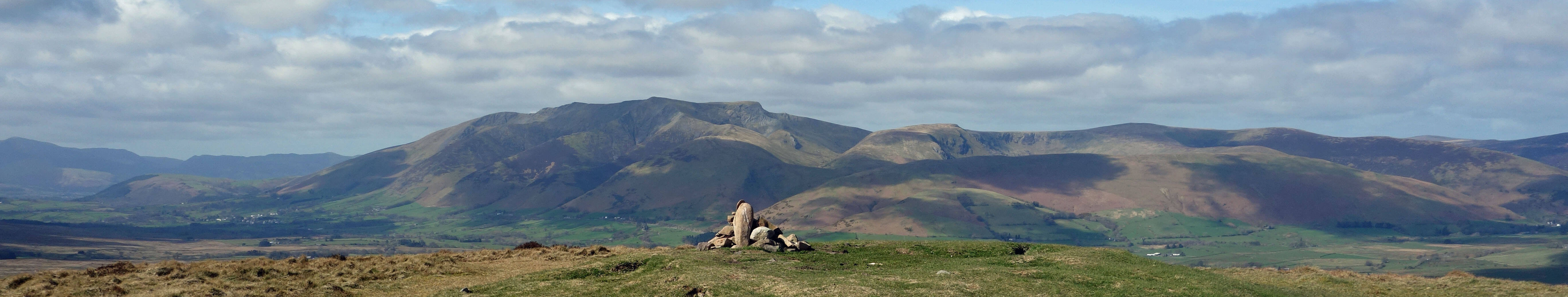
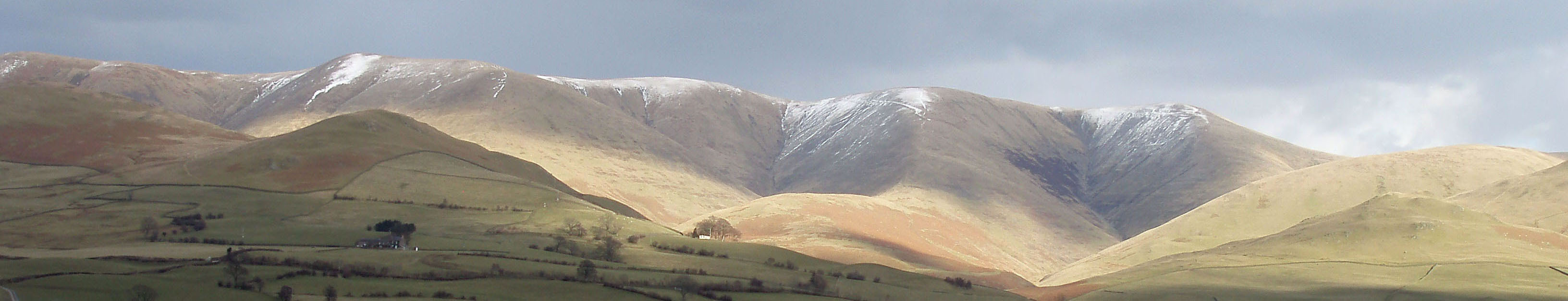
Top photo: The western Howgills from Dillicar;
Bottom photo: Blencathra from Great Mell Fell